Datei:Map-of-Ottoman-Empire-in-1900-Latvian.svg

Gröössi vor PNG-Vorschou vor SVG-Datei: 800 × 504 Pixel. Wyteri Ufflösige: 320 × 201 Pixel | 640 × 403 Pixel | 1.024 × 644 Pixel | 1.280 × 806 Pixel | 2.560 × 1.611 Pixel | 885 × 557 Pixel.
Originaldatei (SVG-Datei, Basisgrößi: 885 × 557 Pixel, Dateigrößi: 103 KB)
| Die Datei un d Informatione derzue were us em zäntrale Mediearchiv Wikimedia Commons (Allmänd) iibunde. | Zur Bschriibigssite uff de Allmänd |
Bschryybig
Kopsavilkums
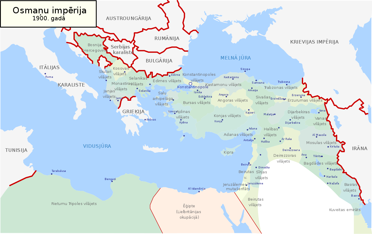
| Bschryybig | Map of Ottoman Empire (1900) in Latvian |
| Datum | |
| Quälle | Eigeni Arbet |
| Urheber | Juris Tiltins |
| Gnähmigung (Wyternutzig vu däre Datei) |
Free use and distribution permitted. |
| Anderi Versione |
Map-of-Ottoman-Empire-in-1900-Latvian.svg[]
|


Lizänzierig
| Ich, dr Urheberrächtsinhaber vu däm Wärch, tue s as gmeinfrej vereffentlige . Des giltet wältwyt. In mänke Staate chennt des rächtli nit megli syy. Wänn des imfall eso isch: Ich gib e jedem s bedingiglos Rächt, des Wärch jedwädere Zwäck z nutze, ußer s git gesetzlig erforderligi Bedingige. |
Dateiversione
Klick uf e Zytpunkt zu aazeige, wie s dert usgsäh het.
| Version vom | Vorschaubild | Mäß | Benutzer | Kommentar | |
|---|---|---|---|---|---|
| aktuell | 19:05, 18. Mai 2018 | | 885 × 557 (103 KB) | NordNordWest | Reverted to version as of 21:53, 30 January 2008 (UTC) |
| 19:04, 18. Mai 2018 |  | 885 × 557 (113 KB) | NordNordWest | + Sicilia, Sardegna, Corse, Malta | |
| 23:53, 30. Jan. 2008 |  | 885 × 557 (103 KB) | Juristiltins | {{Information |Description=Map of Ottoman Empire (1900) in Latvian |Source=own work |Date=30 January 2008 |Author=Juris Tiltins |Permission=Free use and distribution permitted. |other_versions= }} Category:Maps of the Ottoman Empire |
Verwändig vu dr Datei
Kei Artikel bruucht die Datei.
Wältwyti Dateinutzig
Die andere Wikis bruche die Datei:
- Gebruch uf de.wikipedia.org
- Gebruch uf lv.wikipedia.org