Datei:Puncak Jaya (NASA astronaut photograph).jpg

Originaldatei (1.280 × 764 Pixel, Dateigrößi: 108 KB, MIME-Typ: image/jpeg)
| Die Datei un d Informatione derzue were us em zäntrale Mediearchiv Wikimedia Commons (Allmänd) iibunde. | Zur Bschriibigssite uff de Allmänd |
.jpg?uselang=als)
Bschryybig
| Bschryybig |
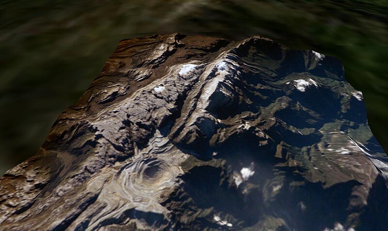
Puncak Jaya, West Papua, Indonesia. The Grasberg (Freeport) copper mine pit is in the foreground, and remnants of the Puncak Jaya glaciers behind. The summit of Puncak Jaya is at the far end of the central rib. Two remnants of the Northwall Firn are to the left of the peak. The Meren Glacier was in the valley between these and the peak, but disappeared sometime between 1994 and 2000[1]. The Carstenz Glacier is immediately right of the peak. (White patches further to the right are clouds, which appear to be on the terrain surface due to the image processing technique used.) At the current retreat rate, all these glaciers will be gone forever inside 10 years, making greater-Australia the first completely ice-free continent on the planet in 100,000 years. (Africa can't win. Kilimanjaro's ice is nearly gone, but there is still a fairly thick glacier left on Mount Kenya, and more in the Ruwenzori.)
worldwind://goto/world=Earth&lat=-4.06986&lon=137.14256&alt=8039&dir=90.3&tilt=52.2 (Imagery mostly cloudy - try Geocover 1990.) Also see |
| Datum | 10. Juni 2006 (Original-Hochladedatum) |
| Quälle |
Made with NASA World Wind from NASA public domain imagery Originally from en.wikipedia; description page is/was here. |
| Urheber | Original uploader was Gergyl at en.wikipedia |
| Gnähmigung (Wyternutzig vu däre Datei) |
Licensed under the GFDL by the author; Released under the GNU Free Documentation License. |
Lizänzierig

|
Des Dokumänt derf kopiert, verbreitet un/oder bearbeitet wäre unter dr Bedingige vu dr GNU-Lizänz fir freji Dokumäntation, Version 1.2 oder ere spetere Version, vereffetligt dur Free Software Foundation. S het keini uuveränderlige Abschnitt, kei vordere Umschlagstext un kei hindere Umschlagstext. E Kopii vu dr Lizänz isch verfiegbar im Abschnitt GNU-Lizänz fir freji Dokumäntation. |
| Die Datei isch lizänziert unter dr Creative-Commons-Lizenz Namensnännig – Wytergab unter glyche Bedingige 3.0 nit portiert. | ||
| Namenännig: Gergyl at the English Wikipedia | ||
| ||
| Die Lizänzmarkierig isch wäg em GFDL-Lizänzupdate zuegfiegt wore. |
Orginal Logbuech vu uffegladene Datei
(All user names refer to en.wikipedia)
- 2006-06-10 09:38 Gergyl 1280×764×8 (110347 bytes)
- 2006-06-10 08:32 Gergyl 1280×764×8 (110462 bytes) Puncak Jaya, Indonesia. A June 2005 NASA astronaut photograph draped over the NASA World Wind SRTM90 DTM and viewed from a similar angle to the 1936 and 1972 USGS photos of this tropical glacier group. worldwind://goto/world=Earth&lat=-4.06651&lon=137.1
Dateiversione
Klick uf e Zytpunkt zu aazeige, wie s dert usgsäh het.
| Version vom | Vorschaubild | Mäß | Benutzer | Kommentar | |
|---|---|---|---|---|---|
| aktuell | 16:45, 26. Apr. 2007 | | 1.280 × 764 (108 KB) | Alfonso"~commonswiki | {{Information |Description=en:Puncak Jaya, en:West Papua, en:Indonesia. The Grasberg (Freeport) copper mine pit is in the foreground, and remnants of the Puncak Jaya glaciers behind. The summ |
Verwändig vu dr Datei
Di folgende Sytene händ en Link zu dem Bildli:
Wältwyti Dateinutzig
Die andere Wikis bruche die Datei:
- Gebruch uf ast.wikipedia.org
- Gebruch uf az.wikipedia.org
- Gebruch uf be-tarask.wikipedia.org
- Gebruch uf be.wikipedia.org
- Gebruch uf ca.wikipedia.org
- Gebruch uf de.wikipedia.org
- Gebruch uf de.wikivoyage.org
- Gebruch uf en.wikipedia.org
- Gebruch uf eo.wikipedia.org
- Gebruch uf es.wikipedia.org
- Gebruch uf eu.wikipedia.org
- Gebruch uf fi.wikipedia.org
- Gebruch uf fr.wikipedia.org
- Gebruch uf hr.wikipedia.org
- Gebruch uf mt.wikipedia.org
- Gebruch uf ru.wikipedia.org
- Gebruch uf sh.wikipedia.org
- Gebruch uf sr.wikipedia.org
- Gebruch uf uk.wikipedia.org
- Gebruch uf vec.wikipedia.org
- Gebruch uf zh.wikipedia.org
.jpg)