Datei:Saint-Martin Island map-fr.svg

Gröössi vor PNG-Vorschou vor SVG-Datei: 796 × 600 Pixel. Wyteri Ufflösige: 319 × 240 Pixel | 637 × 480 Pixel | 1.020 × 768 Pixel | 1.280 × 964 Pixel | 2.560 × 1.928 Pixel | 1.102 × 830 Pixel.
Originaldatei (SVG-Datei, Basisgrößi: 1.102 × 830 Pixel, Dateigrößi: 867 KB)
| Die Datei un d Informatione derzue were us em zäntrale Mediearchiv Wikimedia Commons (Allmänd) iibunde. | Zur Bschriibigssite uff de Allmänd |
Bschryybig
| Kameraposition | | Dieses und weitere Bilder auf OpenStreetMap |
|---|
| Bschryybig |
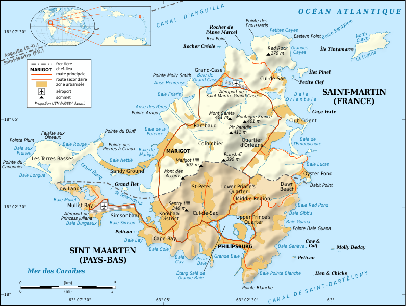
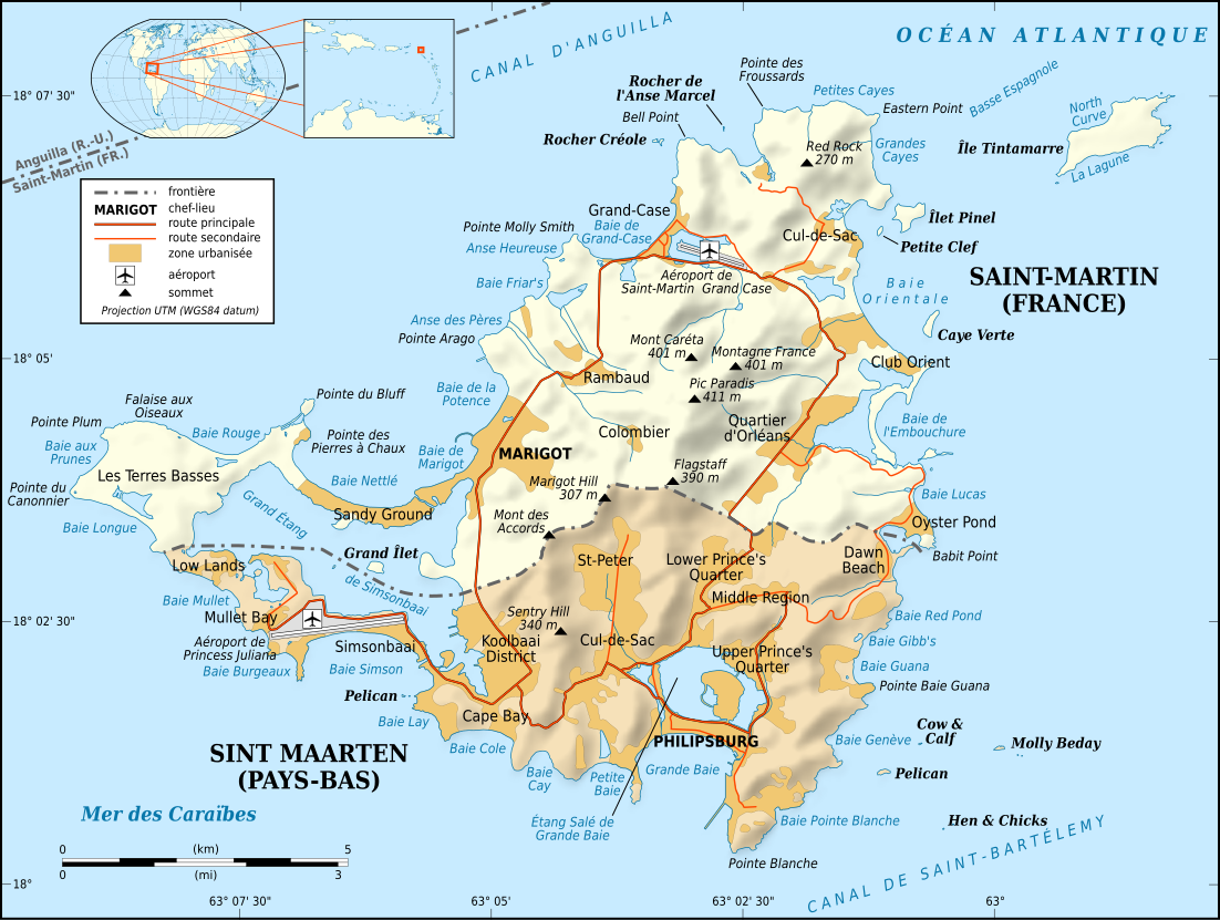
English: Map in French of the Caribbean island of Saint-Martin / Sint Maarten, divided between French and Dutch halves.
Note: the shaded relief is a raster image embedded in the SVG file. Français : Carte en français de l'île de Saint-Martin / Sint Maarten dans les Antilles, divisée en une partie française et une partie néerlandaise. Note : les ombres du relief sont une image bitmap embarquée dans le fichier SVG.
|
||
| Datum | |||
| Quälle |
Own work
|
||
| Urheber | Eric Gaba (Sting - fr:Sting) | ||
| Gnähmigung (Wyternutzig vu däre Datei) |
|
||
| Anderi Versione |
[]
Same base map but smaller and without topography:
|


|
This SVG file contains embedded text that can be translated into your language, using any capable SVG editor, text editor or the SVG Translate tool. For more information see: About translating SVG files. |
Lizänzierig
Ich haa s Urheberrächt an däm Wärch un vereffetlig s dodermit unter däne Lizänze:

|
Des Dokumänt derf kopiert, verbreitet un/oder bearbeitet wäre unter dr Bedingige vu dr GNU-Lizänz fir freji Dokumäntation, Version 1.2 oder ere spetere Version, vereffetligt dur Free Software Foundation. S het keini uuveränderlige Abschnitt, kei vordere Umschlagstext un kei hindere Umschlagstext. E Kopii vu dr Lizänz isch verfiegbar im Abschnitt GNU-Lizänz fir freji Dokumäntation. |
This file is licensed under the Creative Commons Attribution-Share Alike 4.0 International, 3.0 Unported, 2.5 Generic, 2.0 Generic and 1.0 Generic license.
- Du derfsch:
- des Wärch an anderi wytergee – des Wärch kopiere, verbreite un ibertrage
- des Wärch verändere – des Wärch aapasse
- Unter däne Bedingige:
- Namenännig – Du muesch aagmässeni Aagabe zum Urheber un dr Rächt mache, e Link zue dr Lizänz zuefiege un aagee, eb Änderige gmacht wore sin. Die Aagabe chenne in ere aagmässene Art gmacht wäre, aber nit eso, ass dr Yydruck entstoht, ass dr Lizänzgeber Dii oder Dyy Gebruch vum Wärch unterstitze un guetheiße.
- Wytergab unter glyche Bedingige – Wänn du des Wärch veränderesch, umwandlesch oder druf ufböusch, no derfsch s Ergebnis nume unter dr glyche oder ere kumpatible Lizänz wie s Orginal vereffetlige.
Du chasch sälber e Lizänz uuswehle.
Dateiversione
Klick uf e Zytpunkt zu aazeige, wie s dert usgsäh het.
| Version vom | Vorschaubild | Mäß | Benutzer | Kommentar | |
|---|---|---|---|---|---|
| aktuell | 19:58, 16. Apr. 2009 | | 1.102 × 830 (867 KB) | Sting | Fonts issues correction |
| 05:42, 17. Jan. 2009 |  | 1.102 × 830 (867 KB) | Sting | == Summary == {{Location|18|04|00|N|63|03|30|W|scale:100000}} <br/> {{Information |Description={{en|Map in French of the Caribbean island of Saint-Martin / Sint Maarten, divided between French and Dutch halves.<br/> ''Note: the shaded |
Verwändig vu dr Datei
Di folgende Sytene händ en Link zu dem Bildli:
Wältwyti Dateinutzig
Die andere Wikis bruche die Datei:
- Gebruch uf ast.wikipedia.org
- Gebruch uf az.wikipedia.org
- Gebruch uf br.wikipedia.org
- Gebruch uf ca.wikipedia.org
- Gebruch uf da.wikipedia.org
- Gebruch uf de.wikipedia.org
- Gebruch uf en.wikipedia.org
- Gebruch uf eo.wikipedia.org
- Gebruch uf fi.wikipedia.org
- Gebruch uf frr.wikipedia.org
- Gebruch uf fr.wikipedia.org
- Saint-Martin (île)
- Histoire de Saint-Martin
- Île Tintamarre
- Saint-Martin (royaume des Pays-Bas)
- Frontière entre la France et les Pays-Bas
- Projet:Cartographie/Cartes standards/France
- Route nationale 7 (Saint-Martin)
- Îlet Pinel
- Wikipédia:Le saviez-vous ?/Anecdotes proposées/Archivage des discussions/Archives/2016-5
- Gebruch uf fr.wikinews.org
- Gebruch uf gl.wikipedia.org
- Gebruch uf it.wikipedia.org
- Gebruch uf it.wikivoyage.org
- Gebruch uf nl.wikipedia.org
- Gebruch uf pt.wikipedia.org
- Gebruch uf ru.wikipedia.org
- Gebruch uf sc.wikipedia.org
- Gebruch uf sv.wikipedia.org
- Gebruch uf to.wikipedia.org
- Gebruch uf www.wikidata.org