Datei:Topographic map of Saint Helena-en.svg

Gröössi vor PNG-Vorschou vor SVG-Datei: 740 × 600 Pixel. Wyteri Ufflösige: 296 × 240 Pixel | 592 × 480 Pixel | 948 × 768 Pixel | 1.264 × 1.024 Pixel | 2.527 × 2.048 Pixel | 802 × 650 Pixel.
Originaldatei (SVG-Datei, Basisgrößi: 802 × 650 Pixel, Dateigrößi: 583 KB)
| Die Datei un d Informatione derzue were us em zäntrale Mediearchiv Wikimedia Commons (Allmänd) iibunde. | Zur Bschriibigssite uff de Allmänd |
Bschryybig
| Bschryybig |
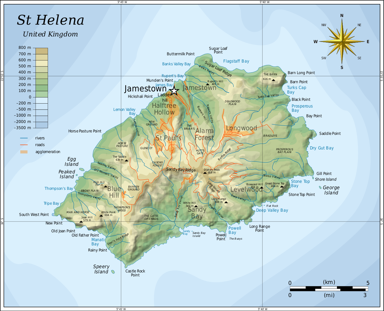
English: Topographic map of the British island of Saint Helena. |
| Datum | |
| Quälle |
Self-made in Inkscape. Based on several sources:
|
| Urheber | Oona Räisänen (Mysid) |
| Anderi Versione |
Abgleiteti Wärk vo dere Datei: |

|
This SVG file contains embedded text that can be translated into your language, using any capable SVG editor, text editor or the SVG Translate tool. For more information see: About translating SVG files. |
Lizänzierig
Ich haa s Urheberrächt an däm Wärch un vereffetlig s dodermit unter däne Lizänze:
Die Datei isch lizänziert unter dr Creative-Commons-Lizenz Namensnännig – Wytergab unter glyche Bedingige 3.0 nit portiert.
- Du derfsch:
- des Wärch an anderi wytergee – des Wärch kopiere, verbreite un ibertrage
- des Wärch verändere – des Wärch aapasse
- Unter däne Bedingige:
- Namenännig – Du muesch aagmässeni Aagabe zum Urheber un dr Rächt mache, e Link zue dr Lizänz zuefiege un aagee, eb Änderige gmacht wore sin. Die Aagabe chenne in ere aagmässene Art gmacht wäre, aber nit eso, ass dr Yydruck entstoht, ass dr Lizänzgeber Dii oder Dyy Gebruch vum Wärch unterstitze un guetheiße.
- Wytergab unter glyche Bedingige – Wänn du des Wärch veränderesch, umwandlesch oder druf ufböusch, no derfsch s Ergebnis nume unter dr glyche oder ere kumpatible Lizänz wie s Orginal vereffetlige.

|
Des Dokumänt derf kopiert, verbreitet un/oder bearbeitet wäre unter dr Bedingige vu dr GNU-Lizänz fir freji Dokumäntation, Version 1.2 oder ere spetere Version, vereffetligt dur Free Software Foundation. S het keini uuveränderlige Abschnitt, kei vordere Umschlagstext un kei hindere Umschlagstext. E Kopii vu dr Lizänz isch verfiegbar im Abschnitt GNU-Lizänz fir freji Dokumäntation. |
Du chasch sälber e Lizänz uuswehle.
Dateiversione
Klick uf e Zytpunkt zu aazeige, wie s dert usgsäh het.
| Version vom | Vorschaubild | Mäß | Benutzer | Kommentar | |
|---|---|---|---|---|---|
| aktuell | 07:54, 10. Aug. 2010 | | 802 × 650 (583 KB) | Mysid | legend for roads, rivers, agglomeration |
| 23:42, 9. Aug. 2010 |  | 802 × 650 (580 KB) | Mysid | bugfix #2 | |
| 23:40, 9. Aug. 2010 |  | 802 × 650 (260 KB) | Mysid | bugfix | |
| 23:27, 9. Aug. 2010 |  | 647 × 594 (579 KB) | Mysid | {{Information |Description={{en|1=Topographic map of the British island of w:Saint Helena.}} |Source=Self-made in Inkscape. Based on several sources. |Author=Mysid |Date=2010-08-10 |Permission= |other_versions= }} {{translation possi |
Verwändig vu dr Datei
Di folgende Sytene händ en Link zu dem Bildli:
Wältwyti Dateinutzig
Die andere Wikis bruche die Datei:
- Gebruch uf af.wikipedia.org
- Gebruch uf ar.wikipedia.org
- Gebruch uf arz.wikipedia.org
- Gebruch uf ast.wikipedia.org
- Gebruch uf bg.wikipedia.org
- Gebruch uf bn.wikipedia.org
- Gebruch uf bs.wikipedia.org
- Gebruch uf ca.wikipedia.org
- Gebruch uf ckb.wikipedia.org
- Gebruch uf da.wikipedia.org
- Gebruch uf el.wikipedia.org
- Gebruch uf en.wikipedia.org
- Gebruch uf eo.wikipedia.org
- Gebruch uf es.wikipedia.org
- Gebruch uf eu.wikipedia.org
- Gebruch uf fa.wikipedia.org
- Gebruch uf fi.wikipedia.org
- Gebruch uf fy.wikipedia.org
- Gebruch uf ga.wikipedia.org
- Gebruch uf gl.wikipedia.org
- Gebruch uf gv.wikipedia.org
- Gebruch uf he.wikipedia.org
- Gebruch uf hr.wikipedia.org
- Gebruch uf hu.wikipedia.org
- Gebruch uf hy.wikipedia.org
- Gebruch uf ie.wikipedia.org
- Gebruch uf io.wikipedia.org
- Gebruch uf it.wikipedia.org
- Gebruch uf ja.wikipedia.org
Wältwyti Verwändig vu däre Datei aaluege.