Plozévet
Plozévet (bretonisch Plozeved) isch e franzesischi Gmai im Département Finistère in dr Region Bretagne.
| Plozévet | |
 | |
| Verwàltung | |
|---|---|
| Land | |
| Region | |
| Département | Finistère (29) |
| Arrondissement | Quimper |
| Kànton | Plonéour-Lanvern |
| Kommünàlverbànd | Haut Pays Bigouden |
| Àmtliga Nàma | Plozévet |
| Maire | Gilles Kerezeon (2014-2020)[1] |
| Code Insee | 29215 |
| Poschtlaitzàhl | 29710 |
| Iiwohner | |
| Iiwohner | 2.940 |
| Flech | 27,18 km2 |
| Bevelkerungsdicht | 109,93 Iiw./km2 |
| Làg | |
| Koordinate | 47° 59′ 12″ N, 4° 25′ 31″ W / 47.986666666667°N,4.4252777777778°WKoordinate: 47° 59′ 12″ N, 4° 25′ 31″ W / 47.986666666667°N,4.4252777777778°W |
| Heche | 70 m |
 Plozévet Plozévet (Frànkrich) | |
| Website | |
| http://www.plozevet.bzh | |
D Gmai ghert zum Kanton Plonéour-Lanvern un zum Arrondissement Quimper.
Geografi ändere
Plozévet lyt am Atlantik, 23 km vu Quimper un 45 km vu Brest uf ere Hechi zwische 0 m un 97 m iber Normalnull.
Gschicht ändere
Plozévet isch zum erschte Mol gnännt wore um 1050 as Vicarium Demett (um 1060 Plebs sancti Demetri, 11. Jh. Vicarium Demet, 11. Jh. Vicario Demett, 1216 Ploechevet, 1216 Ploechevet in armorico in Capcaval, 1216 Ploetheuet).
Verwaltig ändere
Dr Maire vu Plozévet isch dr Gilles Kerezeon. Plozévet ghert zum Kommunalverband Haut Pays Bigouden.
Bevelkerigsentwicklig ändere
| Johr | 1962 | 1968 | 1975 | 1982 | 1990 | 1999 | 2008 |
| Inwohner | 3.675 | 3.541 | 3.249 | 3.102 | 2.838 | 2.748 | 2.943 |
Dialekt ändere
Dr traditionäll Dialäkt vu Plozévet ghert zem Bretonisch.
Kultur un Böuwärch ändere
- Chilche Saint-Demet
- Kapäll de la Trinité
- Kapäll Saint Démet
- Kapäll Saint Renan
- Menhir commémoratif du naufrage du Droits-de-l'Homme
Bilder ändere
-
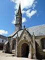
Chilche Saint-Demet -

Kapäll de la Trinité -

Kapäll Saint Démet -

Menhir du Droits-de-l'Homme


.jpg)
Partnergmaine ändere
 Hartland, Verainigts Chenigrych
 Cloghane-Brandon, Irland
Weblink ändere
Fueßnote ändere
- ↑ Liste des maires au 25 avril 2014 (data.gouv.fr)