Datei:Congo Kinshasa Topography.png

Greßi vu däre Vorschau: 664 × 600 Pixel. Wyteri Ufflösige: 266 × 240 Pixel | 531 × 480 Pixel | 850 × 768 Pixel | 1.134 × 1.024 Pixel | 1.437 × 1.298 Pixel.
Originaldatei (1.437 × 1.298 Pixel, Dateigrößi: 3,03 MB, MIME-Typ: image/png)
| Die Datei un d Informatione derzue were us em zäntrale Mediearchiv Wikimedia Commons (Allmänd) iibunde. | Zur Bschriibigssite uff de Allmänd |
Bschryybig
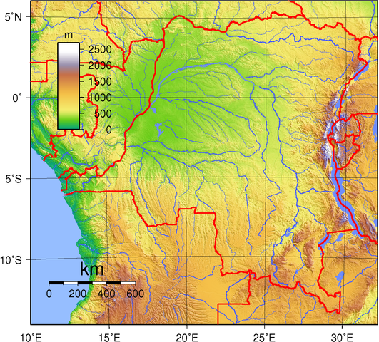
| Bschryybig | Topographic map of Congo (Kinshasa). Created with GMT from GLOBE data. |
| Datum | |
| Quälle | Eigeni Arbet |
| Urheber | Sadalmelik |
Lizänzierig
| Des Wärch isch vu syym Urheber I, Sadalmelik as gmeinfrej vereffentligt wore. Des giltet wältwyt. In mänke Staate chennt des rächtli nit megli syy. Wänn des imfall eso isch: I, Sadalmelik git e jedem s bedingigslos Rächt, des Wärch fir jedwädere Zwäck z nutze, ußer s git gesetzlig erforderligi Bedingige. |
Dateiversione
Klick uf e Zytpunkt zu aazeige, wie s dert usgsäh het.
| Version vom | Vorschaubild | Mäß | Benutzer | Kommentar | |
|---|---|---|---|---|---|
| aktuell | 21:34, 29. Jun. 2007 | | 1.437 × 1.298 (3,03 MB) | Sadalmelik | Better data/colours |
| 10:47, 22. Jun. 2007 |  | 1.460 × 1.298 (2,23 MB) | Sadalmelik | {{Information |Description=Topographic map of Congo (Kinshasa). Created with GMT from GLOBE data. |Source=self-made |Date=June 22, 2007 |Author= Sadalmelik }} Category:Maps of the Democratic Republic of the Congo [[Category:Topogr |
Verwändig vu dr Datei
Di folgende Sytene händ en Link zu dem Bildli:
Wältwyti Dateinutzig
Die andere Wikis bruche die Datei:
- Gebruch uf avk.wikipedia.org
- Gebruch uf da.wikipedia.org
- Gebruch uf de.wikipedia.org
- Gebruch uf en.wikipedia.org
- Gebruch uf eo.wikipedia.org
- Gebruch uf fa.wikipedia.org
- Gebruch uf fr.wikipedia.org
- Gebruch uf hu.wikipedia.org
- Gebruch uf ja.wikipedia.org
- Gebruch uf ka.wikipedia.org
- Gebruch uf mdf.wikipedia.org
- Gebruch uf uk.wikipedia.org
- Gebruch uf vep.wikipedia.org
- Gebruch uf www.wikidata.org
- Gebruch uf zh.wikipedia.org