Datei:DominanzSchartenhoeheNew.png

Greßi vu däre Vorschau: 487 × 600 Pixel. Wyteri Ufflösige: 195 × 240 Pixel | 390 × 480 Pixel | 624 × 768 Pixel | 831 × 1.024 Pixel | 1.736 × 2.138 Pixel.
Originaldatei (1.736 × 2.138 Pixel, Dateigrößi: 915 KB, MIME-Typ: image/png)
| Die Datei un d Informatione derzue were us em zäntrale Mediearchiv Wikimedia Commons (Allmänd) iibunde. | Zur Bschriibigssite uff de Allmänd |

|
Dieses Bild des Typs Graph sollte als Vektorgrafik im SVG-Format neu erstellt werden. Vektorformate haben zahlreiche Vorteile; weitere Information unter Commons:Media for cleanup. Wenn dir eine SVG-Version dieses Bildes vorliegt, so lade diese bitte hoch. Nach dem Hochladen der Datei ist diese Vorlage auf der aktuellen Bildbeschreibungsseite durch die Vorlage {{Vector version available}}, oder kürzer {{Vva}}, zu ersetzen. Es ist empfohlen die neue SVG-Datei „DominanzSchartenhoeheNew.svg“ zu nennen – dann benötigt die Vorlage vector version available (bzw. vva) keinen Parameter.
|
Bschryybig
| Bschryybig |
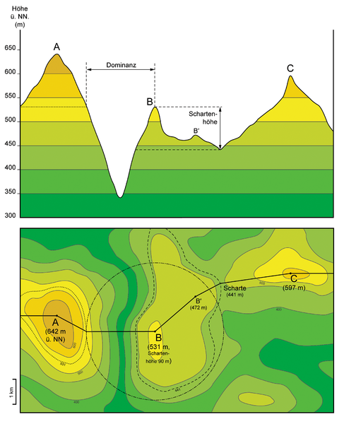
English: Top figure: Projection of terrain elevation along solid black line in the lower figure. Criteria for topographic isolation (Dominanz) and prominence (Schartenhöhe) are given for summit “B”.
Bottom figure: Corresponding topographic map. Dashed black line corresponds to the lowest contour line encircling summit “B” but no higher summit. Black dash-dot line delineates circular area of topographic isolation of summit “B”. Dotted black line corresponds to the contour line on summit “A” which is tangent to the “isolation circle” of summit “B”. Deutsch: Oben: Projektion der Topographie entlang der durchgezogenen schwarzen Linie in der unteren Abbildung. Eingezeichnet sind Dominanz und Schartenhöhe für Berg „B“. Unten: Entsprechende topographische Karte. Die gestrichelte schwarze Linie entspricht der niedrigsten Höhenlinie, die Berg „B“ einschließt aber keinen höheren Gipfel. Die schwarze Strichpunktlinie umreißt die Kreisfläche, die durch die Dominanz von Berg „B“ definiert ist. Die gepunktete schwarze Linie entspricht der Höhenlinie auf den Flanken von Berg „A“, die den „Dominanzkreis“ von Berg „B“ tangiert. |
| Datum | |
| Quälle | Eigeni Arbet : fiktional example with the known definitions of the subject implemented |
| Urheber | Gretarsson |
Lizänzierig
Ich haa s Urheberrächt an däm Wärch un vereffetlig s dodermit unter däne Lizänze:

|
Des Dokumänt derf kopiert, verbreitet un/oder bearbeitet wäre unter dr Bedingige vu dr GNU-Lizänz fir freji Dokumäntation, Version 1.2 oder ere spetere Version, vereffetligt dur Free Software Foundation. S het keini uuveränderlige Abschnitt, kei vordere Umschlagstext un kei hindere Umschlagstext. E Kopii vu dr Lizänz isch verfiegbar im Abschnitt GNU-Lizänz fir freji Dokumäntation. |
Die Datei isch lizänziert unter dr Creative-Commons-Lizänze Namensnännig – Wytergab unter glyche Bedingige 3.0 nit portiert, 2.5 generisch, 2.0 generisch un 1.0 generisch.
- Du derfsch:
- des Wärch an anderi wytergee – des Wärch kopiere, verbreite un ibertrage
- des Wärch verändere – des Wärch aapasse
- Unter däne Bedingige:
- Namenännig – Du muesch aagmässeni Aagabe zum Urheber un dr Rächt mache, e Link zue dr Lizänz zuefiege un aagee, eb Änderige gmacht wore sin. Die Aagabe chenne in ere aagmässene Art gmacht wäre, aber nit eso, ass dr Yydruck entstoht, ass dr Lizänzgeber Dii oder Dyy Gebruch vum Wärch unterstitze un guetheiße.
- Wytergab unter glyche Bedingige – Wänn du des Wärch veränderesch, umwandlesch oder druf ufböusch, no derfsch s Ergebnis nume unter dr glyche oder ere kumpatible Lizänz wie s Orginal vereffetlige.
Du chasch sälber e Lizänz uuswehle.
Dateiversione
Klick uf e Zytpunkt zu aazeige, wie s dert usgsäh het.
| Version vom | Vorschaubild | Mäß | Benutzer | Kommentar | |
|---|---|---|---|---|---|
| aktuell | 00:18, 28. Sep. 2016 | | 1.736 × 2.138 (915 KB) | Cmdrjameson | Compressed with pngout. Reduced by 606kB (39% decrease). |
| 17:14, 13. Nov. 2013 |  | 1.736 × 2.138 (1,49 MB) | Gretarsson | "Terrain profile" drawing is not based on a vertical section anymore but is mainly a projection. Topographic map in lower figure is largely altered in order to obtain a "profile" which is still similar to that of the previous image version. | |
| 19:36, 12. Nov. 2013 |  | 1.736 × 2.077 (1,36 MB) | Gretarsson | {{Information |Description ={{en|1=Top image: Section along X-X' line in lower image. Criteria for topographic isolation (Dominanz) and prominence (Schartenhöhe) are given for summit B. Bottom image: Corresponding topographic map. Dashed black line... |
Verwändig vu dr Datei
Di folgende Sytene händ en Link zu dem Bildli:
Wältwyti Dateinutzig
Die andere Wikis bruche die Datei:
- Gebruch uf de.wikipedia.org
- Gebruch uf es.wikibooks.org
- Gebruch uf frr.wikipedia.org