Datei:Guam satellite photo map.jpg

Greßi vu däre Vorschau: 407 × 599 Pixel. Wyteri Ufflösige: 163 × 240 Pixel | 576 × 848 Pixel.
Originaldatei (576 × 848 Pixel, Dateigrößi: 38 KB, MIME-Typ: image/jpeg)
| Die Datei un d Informatione derzue were us em zäntrale Mediearchiv Wikimedia Commons (Allmänd) iibunde. | Zur Bschriibigssite uff de Allmänd |
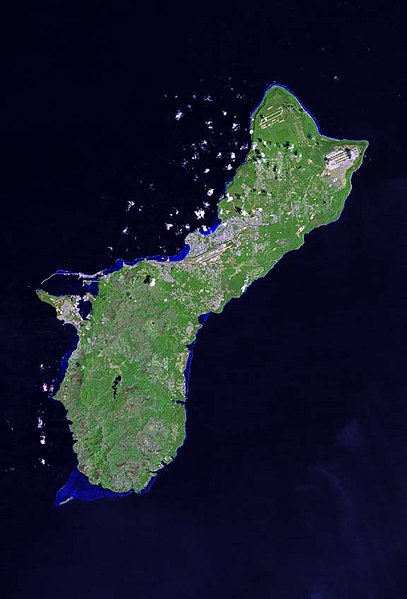
| Bschryybig | The raw satellite imagery shown in these images was obtain from NASA and/or the US Geological Survey. Post-processing and production by www.terraprints.com |
| Datum | |
| Quälle | www.terraprints.com |
| Urheber | http://www.terraprints.com |
Die Datei isch lizänziert unter dr Creative-Commons-Lizänz Namensnännig 2.5 generisch.
- Du derfsch:
- des Wärch an anderi wytergee – des Wärch kopiere, verbreite un ibertrage
- des Wärch verändere – des Wärch aapasse
- Unter däne Bedingige:
- Namenännig – Du muesch aagmässeni Aagabe zum Urheber un dr Rächt mache, e Link zue dr Lizänz zuefiege un aagee, eb Änderige gmacht wore sin. Die Aagabe chenne in ere aagmässene Art gmacht wäre, aber nit eso, ass dr Yydruck entstoht, ass dr Lizänzgeber Dii oder Dyy Gebruch vum Wärch unterstitze un guetheiße.
Dateiversione
Klick uf e Zytpunkt zu aazeige, wie s dert usgsäh het.
| Version vom | Vorschaubild | Mäß | Benutzer | Kommentar | |
|---|---|---|---|---|---|
| aktuell | 03:54, 1. Mär. 2011 | | 576 × 848 (38 KB) | Ras67 | losslessly cropped with Jpegcrop |
| 20:34, 25. Okt. 2006 |  | 671 × 1.000 (52 KB) | Terraprints | {{Information |Description=The raw satellite imagery shown in these images was obtain from NASA and/or the US Geological Survey. Post-processing and production by http://www.terraprints.com |Source=http://www.terraprints.com |Date=20061025 |Author=http:// |
Verwändig vu dr Datei
Di folgende Sytene händ en Link zu dem Bildli:
Wältwyti Dateinutzig
Die andere Wikis bruche die Datei:
- Gebruch uf ch.wikipedia.org
- Gebruch uf de.wikipedia.org
- Gebruch uf de.wiktionary.org
- Gebruch uf en.wikipedia.org
- Gebruch uf ka.wiktionary.org