Datei:LA County Incorporated Areas Los Angeles highlighted.svg

Gröössi vor PNG-Vorschou vor SVG-Datei: 730 × 599 Pixel. Wyteri Ufflösige: 292 × 240 Pixel | 585 × 480 Pixel | 935 × 768 Pixel | 1.247 × 1.024 Pixel | 2.494 × 2.048 Pixel | 950 × 780 Pixel.
Originaldatei (SVG-Datei, Basisgrößi: 950 × 780 Pixel, Dateigrößi: 261 KB)
| Die Datei un d Informatione derzue were us em zäntrale Mediearchiv Wikimedia Commons (Allmänd) iibunde. | Zur Bschriibigssite uff de Allmänd |
Bschryybig
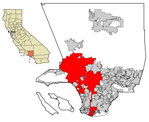
| Bschryybig | This map shows the incorporated areas in Los Angeles County, California. Los Angeles is highlighted in red. I created it in Inkscape using data from the Los Angeles County Website (Los Angeles County Incorporated Area and District Map (PDF). |
| Datum | |
| Quälle | My own work, based on public domain information. Though I strove to be as accurate in the detail as possible, the information shown is not guaranteed to be completely accurate. |
| Urheber | Ixnayonthetimmay |
| Gnähmigung (Wyternutzig vu däre Datei) |
Public Domain |
| Anderi Versione | See Category:Maps of Los Angeles County, California for other versions of this image. |
Lizänzierig
| Ich, dr Urheberrächtsinhaber vu däm Wärch, tue s as gmeinfrej vereffentlige . Des giltet wältwyt. In mänke Staate chennt des rächtli nit megli syy. Wänn des imfall eso isch: Ich gib e jedem s bedingiglos Rächt, des Wärch jedwädere Zwäck z nutze, ußer s git gesetzlig erforderligi Bedingige. |
Dateiversione
Klick uf e Zytpunkt zu aazeige, wie s dert usgsäh het.
| Version vom | Vorschaubild | Mäß | Benutzer | Kommentar | |
|---|---|---|---|---|---|
| aktuell | 09:19, 26. Jun. 2007 | | 950 × 780 (261 KB) | Ixnayonthetimmay | == Summary == {{Information |Description=This map shows the incorporated areas in Los Angeles County, California. Los Angeles is highlighted in |
Verwändig vu dr Datei
Di folgende Sytene händ en Link zu dem Bildli:
Wältwyti Dateinutzig
Die andere Wikis bruche die Datei:
- Gebruch uf af.wikipedia.org
- Gebruch uf ang.wikipedia.org
- Gebruch uf ar.wikipedia.org
- Gebruch uf arz.wikipedia.org
- Gebruch uf ast.wikipedia.org
- Gebruch uf azb.wikipedia.org
- Gebruch uf bg.wikipedia.org
- Gebruch uf bh.wikipedia.org
- Gebruch uf bn.wikipedia.org
- Gebruch uf ca.wikipedia.org
- Gebruch uf chy.wikipedia.org
- Gebruch uf de.wikipedia.org
- Gebruch uf diq.wikipedia.org
- Gebruch uf dty.wikipedia.org
- Gebruch uf el.wikipedia.org
- Gebruch uf en.wikipedia.org
- Los Angeles
- Los Angeles Police Department
- Harbor Gateway, Los Angeles
- Municipal annexation in the United States
- Category:Neighborhoods in Los Angeles
- National Register of Historic Places listings in Los Angeles
- Killing of Ezell Ford
- Wikipedia talk:WikiProject China/Archive 26
- Talk:New York (state)/Archive 7
- User:Hparham865
- User:Nate.beisheim/sandbox10
- Gebruch uf en.wikinews.org
- Gebruch uf es.wikipedia.org
- Gebruch uf eu.wikipedia.org
- Gebruch uf ext.wikipedia.org
- Gebruch uf fa.wikipedia.org
- Gebruch uf fi.wikipedia.org
- Gebruch uf fo.wikipedia.org
- Gebruch uf fr.wikipedia.org
- Los Angeles
- Projet:Charte graphique/Domaine géographique
- Los Angeles Police Department
- Modèle:Infobox Ville des États-Unis
- Modèle:Infobox Ville des États-Unis/Documentation
- Gangster Squad (LAPD)
- Community Resources Against Street Hoodlums
- Division métropolitaine du Los Angeles Police Department
- Modèle:Infobox Ville des États-Unis/Bac à sable
- Gebruch uf fr.wikinews.org
- Gebruch uf fy.wikipedia.org
- Gebruch uf ga.wikipedia.org
Wältwyti Verwändig vu däre Datei aaluege.