Datei:Map of Assyria.png
Greßi vu däre Vorschau: 800 × 550 Pixel. Wyteri Ufflösige: 320 × 220 Pixel | 640 × 440 Pixel | 1.024 × 704 Pixel | 1.280 × 880 Pixel | 1.983 × 1.363 Pixel.
Originaldatei (1.983 × 1.363 Pixel, Dateigrößi: 160 KB, MIME-Typ: image/png)
| Die Datei un d Informatione derzue were us em zäntrale Mediearchiv Wikimedia Commons (Allmänd) iibunde. | Zur Bschriibigssite uff de Allmänd |
| Bschryybig |
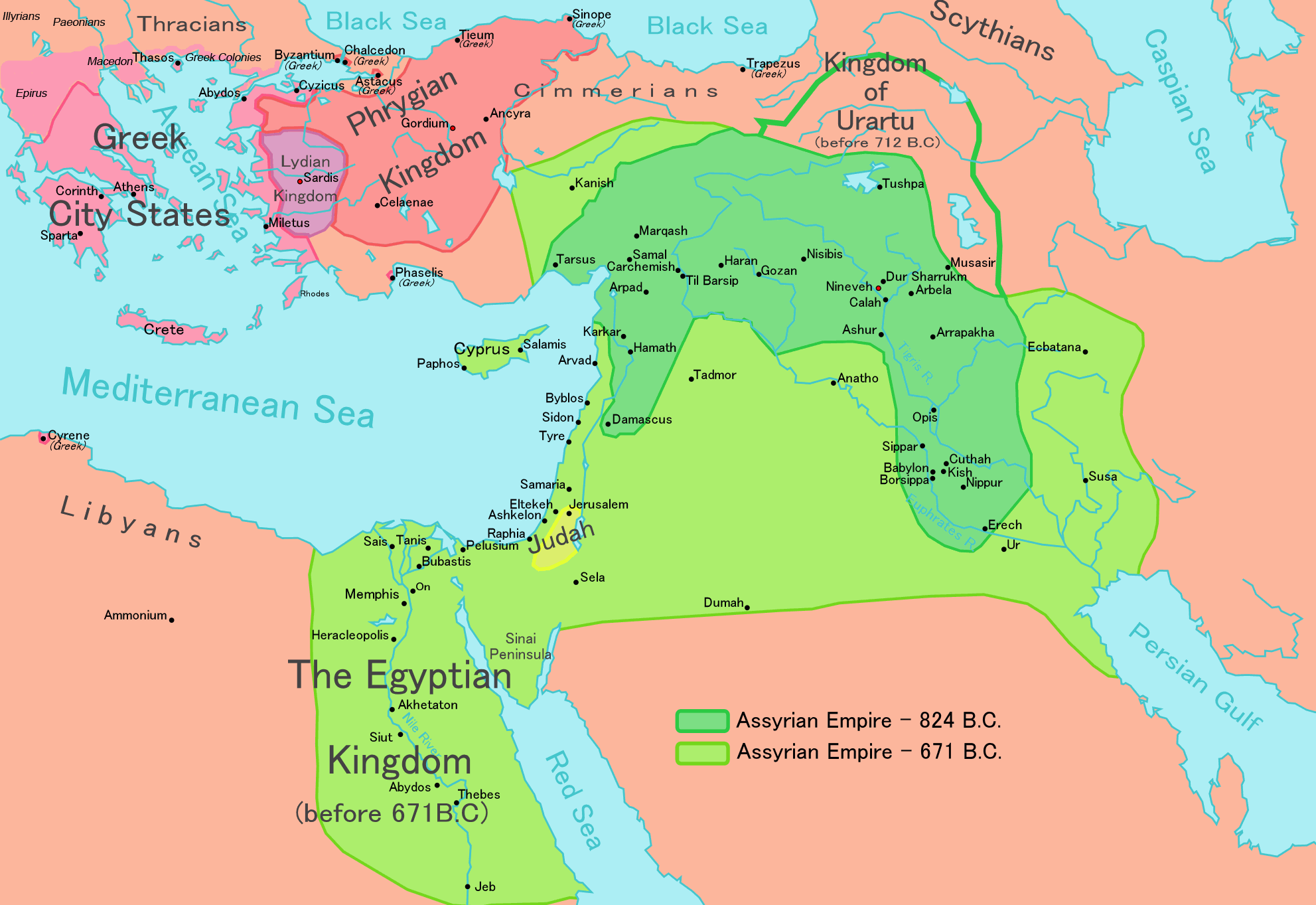
[] English: Map of the Assyrian Empire Español: Extensión del Imperio Asirio Polski: Mapa Asyrii w 824 i 671 r. p.n.e. Português: Extensão do Império Assírio العربية : خارطة الإمبراطوريَّة الآشوريَّة. فارسی : نقشه امپراتوری آشور |
|||
| Datum | ||||
| Quälle |
Own work data from
|
|||
| Urheber | Ningyou | |||
| Gnähmigung (Wyternutzig vu däre Datei) |
|
|||
| Anderi Versione |
[]
|


Dateiversione
Klick uf e Zytpunkt zu aazeige, wie s dert usgsäh het.
| Version vom | Vorschaubild | Mäß | Benutzer | Kommentar | |
|---|---|---|---|---|---|
| aktuell | 14:32, 24. Mai 2018 | | 1.983 × 1.363 (160 KB) | Capmo | corrected typos in Trapezus and Hamath |
| 20:33, 12. Sep. 2010 |  | 1.983 × 1.363 (148 KB) | Ras67 | cropped and squeezed | |
| 02:35, 1. Sep. 2010 |  | 1.985 × 1.365 (161 KB) | Capmo | typo in word "Aegean"; 256 colors | |
| 23:05, 21. Jan. 2010 |  | 1.985 × 1.365 (645 KB) | Megistias | Border around map, Details | |
| 16:51, 26. Feb. 2006 |  | 1.985 × 1.365 (640 KB) | Ningyou | This is a large map of Assyria, made by Ningyou. For translations of this map, contact Ningyou. Category:Assyria |
Verwändig vu dr Datei
Di folgende Sytene händ en Link zu dem Bildli:
Wältwyti Dateinutzig
Die andere Wikis bruche die Datei:
- Gebruch uf af.wikipedia.org
- Gebruch uf am.wikipedia.org
- Gebruch uf an.wikipedia.org
- Gebruch uf arc.wikipedia.org
- Gebruch uf ar.wikipedia.org
- Gebruch uf ast.wikipedia.org
- Gebruch uf azb.wikipedia.org
- Gebruch uf az.wikipedia.org
- Gebruch uf ba.wikipedia.org
- Gebruch uf be.wikipedia.org
- Gebruch uf bg.wikipedia.org
- Gebruch uf bn.wikipedia.org
- Gebruch uf ca.wikipedia.org
- Gebruch uf ckb.wikipedia.org
- Gebruch uf cs.wikipedia.org
- Gebruch uf cv.wikipedia.org
- Gebruch uf cy.wikipedia.org
- Gebruch uf dag.wikipedia.org
- Gebruch uf da.wikipedia.org
- Gebruch uf de.wikipedia.org
- Gebruch uf el.wikipedia.org
Wältwyti Verwändig vu däre Datei aaluege.