Datei:North Korea 1996 CIA map.jpg

Originaldatei (1.608 × 2.000 Pixel, Dateigrößi: 1,67 MB, MIME-Typ: image/jpeg)
| Die Datei un d Informatione derzue were us em zäntrale Mediearchiv Wikimedia Commons (Allmänd) iibunde. | Zur Bschriibigssite uff de Allmänd |
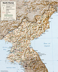
North Korea
CREATED/PUBLISHED [Washington, D.C. : Central Intelligence Agency, 1996]
NOTES Relief shown by shading and spot heights.
"Base 802497 (546979) 6-96."
Scale [ca. 1:3,500,000] ; Lambert conformal conic proj., SP 36N/40N (E 124 deg--E 130 deg/N 43 deg--N 37 deg).
SUBJECTS Korea (North)--Maps. Korea (North).
MEDIUM 1 map : col. ; 21 x 17 cm.
CALL NUMBER G7905 1996 .U5
REPOSITORY Library of Congress Geography and Map Division Washington, D.C. 20540-4650 USA
http://hdl.loc.gov/loc.gmd/g7905.ct001221
| Dieses Bild ist eine Arbeit eines CIA-Mitarbeiters. Als ein Werk der Regierung der Vereinigten Staaten ist dieses Bild in den USA gemeinfrei.
|

|
derivative works
Abgleiteti Wärk vo dere Datei: South hwanghae counties.png
Dateiversione
Klick uf e Zytpunkt zu aazeige, wie s dert usgsäh het.
| Version vom | Vorschaubild | Mäß | Benutzer | Kommentar | |
|---|---|---|---|---|---|
| aktuell | 01:10, 26. Okt. 2005 | | 1.608 × 2.000 (1,67 MB) | Brian0918 | North Korea CREATED/PUBLISHED [Washington, D.C. : Central Intelligence Agency, 1996] NOTES Relief shown by shading and spot heights. "Base 802497 (546979) 6-96." Scale [ca. 1:3,500,000] ; Lambert conformal conic proj., SP 36N/40N (E 124 deg--E 130 deg |
Verwändig vu dr Datei
Di folgende Sytene händ en Link zu dem Bildli:
Wältwyti Dateinutzig
Die andere Wikis bruche die Datei:
- Gebruch uf af.wikipedia.org
- Gebruch uf ar.wikipedia.org
- Gebruch uf ast.wikipedia.org
- Gebruch uf bs.wikipedia.org
- Gebruch uf ca.wikipedia.org
- Gebruch uf de.wikipedia.org
- Gebruch uf el.wikipedia.org
- Gebruch uf en.wikipedia.org
- Gebruch uf eo.wikipedia.org
- Gebruch uf es.wikipedia.org
- Gebruch uf fa.wikipedia.org
- Gebruch uf fi.wikipedia.org
- Gebruch uf frp.wikipedia.org
- Gebruch uf he.wikipedia.org
- Gebruch uf hy.wikipedia.org
- Gebruch uf id.wikipedia.org
- Gebruch uf io.wikipedia.org
- Gebruch uf jv.wikipedia.org
- Gebruch uf ku.wikipedia.org
- Gebruch uf la.wikipedia.org
- Gebruch uf lb.wikipedia.org
- Gebruch uf lt.wikipedia.org
- Gebruch uf nds.wikipedia.org
- Gebruch uf nl.wikinews.org
- Gebruch uf oc.wikipedia.org
- Gebruch uf pl.wikipedia.org
- Gebruch uf pt.wikipedia.org
- Gebruch uf qu.wikipedia.org
- Gebruch uf th.wikipedia.org
- Gebruch uf uk.wikipedia.org
- Gebruch uf vi.wikipedia.org