Datei:Pacific Ring of Fire.png
Greßi vu däre Vorschau: 800 × 593 Pixel. Wyteri Ufflösige: 320 × 237 Pixel | 640 × 475 Pixel | 1.024 × 760 Pixel | 1.046 × 776 Pixel.
Originaldatei (1.046 × 776 Pixel, Dateigrößi: 66 KB, MIME-Typ: image/png)
| Die Datei un d Informatione derzue were us em zäntrale Mediearchiv Wikimedia Commons (Allmänd) iibunde. | Zur Bschriibigssite uff de Allmänd |

|
Please translate the English parts of this template into Alemannisch.
Säll Bild gitt's au in als Vektorgrafik (SVG). It should be used in place of this raster image. File:Pacific Ring of Fire.png → File:Pacific Ring of Fire.svg
Meh zu Vektorgrafike findsch unter Wechsel zu SVG. Zu de Unterstützig vu SVG durch d'MediaWiki-Software lüeg unter SVG image support uff Meta. |
 |
Bschryybig
| Bschryybig |
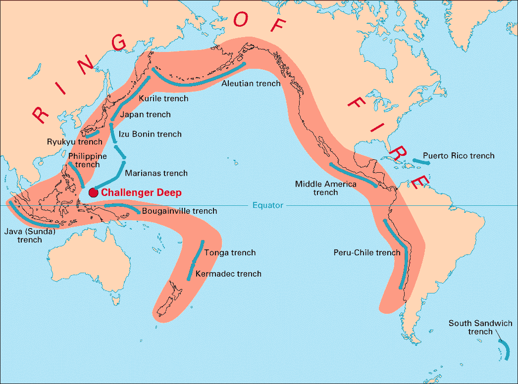
English: Volcanic arcs and oceanic trenches partly encircling the Pacific Basin form the so-called Pacific Ring of fire, a zone of frequent earthquakes and volcanic eruptions. The trenches are shown in blue-green. The volcanic island arcs, although not labelled, are parallel to, and always landward of, the trenches. For example, the island arc associated with the Aleutian Trench is represented by the long chain of volcanoes that make up the Aleutian Islands. |
| Datum | |
| Quälle | http://pubs.usgs.gov/publications/text/fire.html |
| Urheber | USGS |
Lizänzierig
Dieses Bild ist gemeinfrei (public domain), weil es Materialien beeinhaltet, die ursprünglich vom United States Geological Survey, einer Behörde des Innenministeriums der Vereinigten Staaten, stammen. Weitere Informationen finden Sie in den Urheberrechtsbestimmungen des USGS
|
Dateiversione
Klick uf e Zytpunkt zu aazeige, wie s dert usgsäh het.
| Version vom | Vorschaubild | Mäß | Benutzer | Kommentar | |
|---|---|---|---|---|---|
| aktuell | 05:28, 28. Dez. 2004 | | 1.046 × 776 (66 KB) | Ævar Arnfjörð Bjarmason | Deeper colours |
| 05:26, 28. Dez. 2004 |  | 1.046 × 776 (156 KB) | Ævar Arnfjörð Bjarmason |
Verwändig vu dr Datei
Di folgende Sytene händ en Link zu dem Bildli:
Wältwyti Dateinutzig
Die andere Wikis bruche die Datei:
- Gebruch uf ar.wikipedia.org
- Gebruch uf ary.wikipedia.org
- Gebruch uf bs.wikipedia.org
- Gebruch uf ca.wikipedia.org
- Gebruch uf da.wikipedia.org
- Gebruch uf dsb.wikipedia.org
- Gebruch uf en.wikipedia.org
- Gebruch uf en.wikibooks.org
- Gebruch uf eo.wikipedia.org
- Gebruch uf eu.wikipedia.org
- Gebruch uf fr.wikipedia.org
- Gebruch uf gl.wikipedia.org
- Gebruch uf hr.wikipedia.org
- Gebruch uf hsb.wikipedia.org
- Gebruch uf id.wikipedia.org
- Gebruch uf it.wikipedia.org
- Gebruch uf ko.wikipedia.org
- Gebruch uf ko.wikinews.org
- Gebruch uf lt.wikipedia.org
- Gebruch uf lv.wikipedia.org
- Gebruch uf mg.wikipedia.org
- Gebruch uf ms.wikipedia.org
- Gebruch uf nia.wikipedia.org
- Gebruch uf nl.wikipedia.org
- Gebruch uf nn.wikipedia.org
- Gebruch uf no.wikipedia.org
- Gebruch uf pap.wikipedia.org
- Gebruch uf pnb.wikipedia.org
- Gebruch uf ro.wikipedia.org
- Gebruch uf simple.wikipedia.org
- Gebruch uf sk.wikipedia.org
- Gebruch uf sl.wikipedia.org
- Gebruch uf sr.wikipedia.org
- Gebruch uf su.wikipedia.org
- Gebruch uf sv.wikipedia.org
Wältwyti Verwändig vu däre Datei aaluege.