Datei:Pfaelzerwaldkarte Wasgau.png

Greßi vu däre Vorschau: 668 × 600 Pixel. Wyteri Ufflösige: 267 × 240 Pixel | 534 × 480 Pixel | 855 × 768 Pixel | 1.140 × 1.024 Pixel | 1.758 × 1.579 Pixel.
Originaldatei (1.758 × 1.579 Pixel, Dateigrößi: 4,36 MB, MIME-Typ: image/png)
| Die Datei un d Informatione derzue were us em zäntrale Mediearchiv Wikimedia Commons (Allmänd) iibunde. | Zur Bschriibigssite uff de Allmänd |
Bschryybig
| Bschryybig |
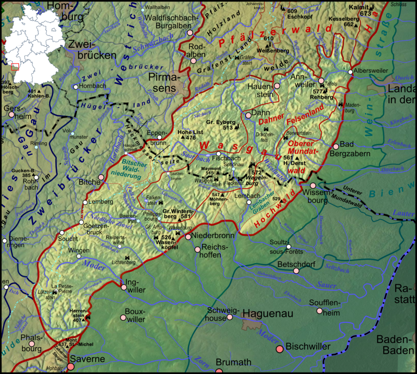
Deutsch: Lagekarte des Wasgau (aufgehellt), des nach Frankreich grenzübergreifenden Südteils des Pfälzerwaldes |
| Datum | |
| Quälle |
Eigeni Arbet
|
| Urheber | Elop, based on work by Lencer |
| Anderi Versione |
|
Lizänzierig

|
Des Dokumänt derf kopiert, verbreitet un/oder bearbeitet wäre unter dr Bedingige vu dr GNU-Lizänz fir freji Dokumäntation, Version 1.2 oder ere spetere Version, vereffetligt dur Free Software Foundation. S het keini uuveränderlige Abschnitt, kei vordere Umschlagstext un kei hindere Umschlagstext. E Kopii vu dr Lizänz isch verfiegbar im Abschnitt GNU-Lizänz fir freji Dokumäntation. |
Dateiversione
Klick uf e Zytpunkt zu aazeige, wie s dert usgsäh het.
| Version vom | Vorschaubild | Mäß | Benutzer | Kommentar | |
|---|---|---|---|---|---|
| aktuell | 23:41, 8. Feb. 2012 | | 1.758 × 1.579 (4,36 MB) | Elop | komplettes Update |
| 03:39, 17. Dez. 2011 |  | 1.382 × 1.137 (2,31 MB) | Elop | Update | |
| 20:39, 11. Dez. 2011 |  | 1.382 × 1.137 (2,25 MB) | Elop | == Summary == {{Information |Description ={{de|1=Lagekarte des de:Wasgau (farblich hervorgehoben), des nach Frankreich grenzübergreifenden Südteils des Pfälzerwaldes}} |Source ={{own}} *[[:File:Karte Pfälzerwald.p |
Verwändig vu dr Datei
Di folgende Sytene händ en Link zu dem Bildli:
Wältwyti Dateinutzig
Die andere Wikis bruche die Datei:
- Gebruch uf de.wikipedia.org
- Gebruch uf en.wikipedia.org
- Gebruch uf eo.wikipedia.org
- Gebruch uf fr.wikipedia.org
- Gebruch uf fr.wiktionary.org
- Gebruch uf pfl.wikipedia.org