Datei:Reliefkarte Waadt.png

Greßi vu däre Vorschau: 632 × 600 Pixel. Wyteri Ufflösige: 253 × 240 Pixel | 506 × 480 Pixel | 809 × 768 Pixel | 1.079 × 1.024 Pixel | 2.158 × 2.048 Pixel | 3.989 × 3.785 Pixel.
Originaldatei (3.989 × 3.785 Pixel, Dateigrößi: 13,31 MB, MIME-Typ: image/png)
| Die Datei un d Informatione derzue were us em zäntrale Mediearchiv Wikimedia Commons (Allmänd) iibunde. | Zur Bschriibigssite uff de Allmänd |
| Bschryybig |
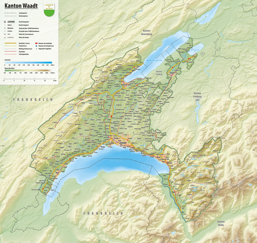
Deutsch: Reliefkarte des Kantons Waadt
Topographischer Hintergrund: NASA Shuttle Radar Topography Mission (public domain). SRTM3 v.2. |
||||||||
| Datum | |||||||||
| Quälle | Eigeni Arbet | ||||||||
| Urheber | Tschubby | ||||||||
| Gnähmigung (Wyternutzig vu däre Datei) |
Ich haa s Urheberrächt an däm Wärch un vereffetlig s dodermit unter däne Lizänze:
Die Datei isch lizänziert unter dr Creative-Commons-Lizänze Namensnännig – Wytergab unter glyche Bedingige 2.5 generisch, 2.0 generisch un 1.0 generisch.
Du chasch sälber e Lizänz uuswehle. |

Dateiversione
Klick uf e Zytpunkt zu aazeige, wie s dert usgsäh het.
| Version vom | Vorschaubild | Mäß | Benutzer | Kommentar | |
|---|---|---|---|---|---|
| aktuell | 18:15, 26. Dez. 2021 | | 3.989 × 3.785 (13,31 MB) | Tschubby | {{Information |Description= |Source= |Date= |Author= |Permission= |other_versions= }} |
| 17:39, 26. Dez. 2021 |  | 3.989 × 3.785 (13,31 MB) | Tschubby | {{Information |Description= |Source= |Date= |Author= |Permission= |other_versions= }} | |
| 20:51, 1. Feb. 2019 |  | 3.989 × 3.785 (13,31 MB) | Tschubby | {{Information |description= |date= |source= |author= |permission= |other versions= }} | |
| 20:21, 10. Mai 2016 |  | 3.325 × 3.156 (7,23 MB) | Tschubby | {{Information |Description= |Source= |Date= |Author= |Permission= |other_versions= }} | |
| 16:46, 20. Aug. 2013 |  | 3.327 × 3.158 (10,43 MB) | Tschubby | {{Information |Description= {{de| Reliefkarte des Kantons Waadt}} Topographischer Hintergrund: [http://www2.jpl.nasa.gov/srtm NASA Shuttle Radar Topography Mission] (public domain). SRTM3 v.2. |Source={{own}} |Date= 2013-08-20 |Author= [[:de:User:Tschu... |
Verwändig vu dr Datei
Di folgende Sytene händ en Link zu dem Bildli:
Wältwyti Dateinutzig
Die andere Wikis bruche die Datei:
- Gebruch uf de.wikipedia.org
- Gebruch uf sv.wikipedia.org