Datei:Tracian state.png

Greßi vu däre Vorschau: 561 × 599 Pixel. Wyteri Ufflösige: 225 × 240 Pixel | 449 × 480 Pixel | 719 × 768 Pixel | 958 × 1.024 Pixel | 1.386 × 1.481 Pixel.
Originaldatei (1.386 × 1.481 Pixel, Dateigrößi: 926 KB, MIME-Typ: image/png)
| Die Datei un d Informatione derzue were us em zäntrale Mediearchiv Wikimedia Commons (Allmänd) iibunde. | Zur Bschriibigssite uff de Allmänd |
Bschryybig
| Bschryybig |
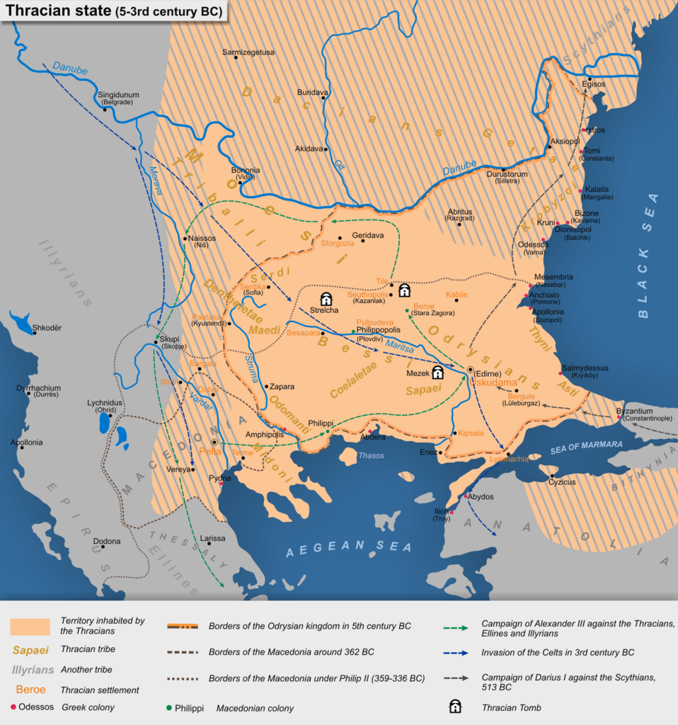
English: Tracian state (5-3rd century BC)
Български: Тракийска държава (5-3 век пр.н.е.)
Based on map "Thracian state (V-III century BC)" in the atlas "Atlas of the history of the Old World," Integrated Research Institute and Design Mapping, Sofia, 1979 (Основана на картата "Тракийска държава (V-III век пр.н.е.)" в "Атлас по история на Стария свят", Комплексен институт за проучване и проектиране по картография, София, 1979 г.) |
| Datum | |
| Quälle | Eigeni Arbet |
| Urheber | Kandi |
Lizänzierig
Ich haa s Urheberrächt an däm Wärch un vereffetlig s dodermit unter däne Lizänze:

|
Des Dokumänt derf kopiert, verbreitet un/oder bearbeitet wäre unter dr Bedingige vu dr GNU-Lizänz fir freji Dokumäntation, Version 1.2 oder ere spetere Version, vereffetligt dur Free Software Foundation. S het keini uuveränderlige Abschnitt, kei vordere Umschlagstext un kei hindere Umschlagstext. E Kopii vu dr Lizänz isch verfiegbar im Abschnitt GNU-Lizänz fir freji Dokumäntation. |
This file is licensed under the Creative Commons Attribution-Share Alike 4.0 International, 3.0 Unported, 2.5 Generic, 2.0 Generic and 1.0 Generic license.
- Du derfsch:
- des Wärch an anderi wytergee – des Wärch kopiere, verbreite un ibertrage
- des Wärch verändere – des Wärch aapasse
- Unter däne Bedingige:
- Namenännig – Du muesch aagmässeni Aagabe zum Urheber un dr Rächt mache, e Link zue dr Lizänz zuefiege un aagee, eb Änderige gmacht wore sin. Die Aagabe chenne in ere aagmässene Art gmacht wäre, aber nit eso, ass dr Yydruck entstoht, ass dr Lizänzgeber Dii oder Dyy Gebruch vum Wärch unterstitze un guetheiße.
- Wytergab unter glyche Bedingige – Wänn du des Wärch veränderesch, umwandlesch oder druf ufböusch, no derfsch s Ergebnis nume unter dr glyche oder ere kumpatible Lizänz wie s Orginal vereffetlige.
Du chasch sälber e Lizänz uuswehle.
Dateiversione
Klick uf e Zytpunkt zu aazeige, wie s dert usgsäh het.
| Version vom | Vorschaubild | Mäß | Benutzer | Kommentar | |
|---|---|---|---|---|---|
| aktuell | 11:10, 26. Dez. 2020 | | 1.386 × 1.481 (926 KB) | Kandi | Reverted to version as of 10:21, 7 October 2013 (UTC) |
| 13:58, 17. Jul. 2019 |  | 1.386 × 1.481 (937 KB) | Julieta39 | Antic shorelines ([https://commons.wikimedia.org/wiki/File:Danube_Delta_evolution.gif]) | |
| 12:21, 7. Okt. 2013 |  | 1.386 × 1.481 (926 KB) | Kandi | Reverted to version as of 07:16, 4 October 2013 | |
| 07:41, 7. Okt. 2013 |  | 1.386 × 1.426 (511 KB) | Jingiby | Thracian presence in Olympus and Pieria and the area west of Axios during 4-3 th century BC contradicted mainstream bibliography. Pella and Lysimachia were marked as Thracian settlements which was wrong. Literary evidence of Greco—Thracian contact du... | |
| 09:16, 4. Okt. 2013 |  | 1.386 × 1.481 (926 KB) | Kandi | Reverted to version as of 20:38, 23 October 2011 | |
| 14:19, 3. Okt. 2013 |  | 1.386 × 1.426 (511 KB) | Jingiby | Corrections of the territories inhabited by Thracians, the borders of their state and the period of the map of the map. | |
| 22:38, 23. Okt. 2011 |  | 1.386 × 1.481 (926 KB) | Kandi | {{Information |Description ={{en|1=Tracian state (5-3rd century BC)}} {{bg|1=Тракийска държава (5-3 век пр.н.е.)}} |Source ={{own}} |Author =Kandi |Date =2011-10-23 |Permission = |othe |
Verwändig vu dr Datei
Di folgende Sytene händ en Link zu dem Bildli:
Wältwyti Dateinutzig
Die andere Wikis bruche die Datei:
- Gebruch uf ar.wikipedia.org
- Gebruch uf bg.wikipedia.org
- Gebruch uf ca.wikipedia.org
- Gebruch uf de.wikipedia.org
- Gebruch uf en.wikipedia.org
- Gebruch uf eo.wikipedia.org
- Gebruch uf es.wikipedia.org
- Gebruch uf et.wikipedia.org
- Gebruch uf fr.wikipedia.org
- Gebruch uf hy.wikipedia.org
- Gebruch uf it.wikipedia.org
- Gebruch uf ka.wikipedia.org
- Gebruch uf ko.wikipedia.org
- Gebruch uf mk.wikipedia.org
- Gebruch uf pl.wikipedia.org
- Gebruch uf rm.wikipedia.org
- Gebruch uf ro.wikipedia.org
- Gebruch uf ru.wikipedia.org
- Gebruch uf sv.wikipedia.org
- Gebruch uf uk.wikipedia.org
- Gebruch uf www.wikidata.org