Datei:Grønland+grid.png

Greßi vu däre Vorschau: 324 × 600 Pixel. Wyteri Ufflösige: 129 × 240 Pixel | 329 × 609 Pixel.
Originaldatei (329 × 609 Pixel, Dateigrößi: 25 KB, MIME-Typ: image/png)
| Die Datei un d Informatione derzue were us em zäntrale Mediearchiv Wikimedia Commons (Allmänd) iibunde. | Zur Bschriibigssite uff de Allmänd |
Bschryybig
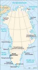
| Bschryybig | Map of Groeland with grid |
| Quälle | CIA World Factbook |
| Urheber | Translator , grid Ulamm 02:54, 14 December 2007 (UTC) |
| Anderi Versione | de:Image:Gl-map.png |

|
Dieses Bild des Typs Map sollte als Vektorgrafik im SVG-Format neu erstellt werden. Vektorformate haben zahlreiche Vorteile; weitere Information unter Commons:Media for cleanup. Wenn dir eine SVG-Version dieses Bildes vorliegt, so lade diese bitte hoch. Nach dem Hochladen der Datei ist diese Vorlage auf der aktuellen Bildbeschreibungsseite durch die Vorlage {{Vector version available}}, oder kürzer {{Vva}}, zu ersetzen. Es ist empfohlen die neue SVG-Datei „Grønland+grid.svg“ zu nennen – dann benötigt die Vorlage vector version available (bzw. vva) keinen Parameter.
|
Lizänzierig
Dieses Werk ist gemeinfrei, weil es Bildmaterial aus dem CIA World Factbook darstellt, das ursprünglich vom Zentralen Nachrichtendienst der Vereinigten Staaten veröffentlicht wurde.
|
 |
Dateiversione
Klick uf e Zytpunkt zu aazeige, wie s dert usgsäh het.
| Version vom | Vorschaubild | Mäß | Benutzer | Kommentar | |
|---|---|---|---|---|---|
| aktuell | 04:54, 14. Dez. 2007 | | 329 × 609 (25 KB) | Ulamm | {{Information |Description=Map of Groeland with grid |Source=CIA World Factbook |Date= |Author=Translator de:Benutzer:Head, grid ~~~~ |Permission= |other_versions=de:Image:Gl-map.png }} |
Verwändig vu dr Datei
Di folgende Sytene händ en Link zu dem Bildli:
Wältwyti Dateinutzig
Die andere Wikis bruche die Datei:
- Gebruch uf af.wikipedia.org
- Gebruch uf de.wikipedia.org
- Gebruch uf de.wikinews.org
- Gebruch uf el.wikipedia.org
- Gebruch uf frr.wikipedia.org
- Gebruch uf ik.wikipedia.org
- Gebruch uf nds.wikipedia.org