Datei:China edcp relief location map.jpg

Greßi vu däre Vorschau: 753 × 600 Pixel. Wyteri Ufflösige: 302 × 240 Pixel | 603 × 480 Pixel | 965 × 768 Pixel | 1.280 × 1.019 Pixel | 1.968 × 1.567 Pixel.
Originaldatei (1.968 × 1.567 Pixel, Dateigrößi: 562 KB, MIME-Typ: image/jpeg)
| Die Datei un d Informatione derzue were us em zäntrale Mediearchiv Wikimedia Commons (Allmänd) iibunde. | Zur Bschriibigssite uff de Allmänd |
Bschryybig
| Bschryybig |
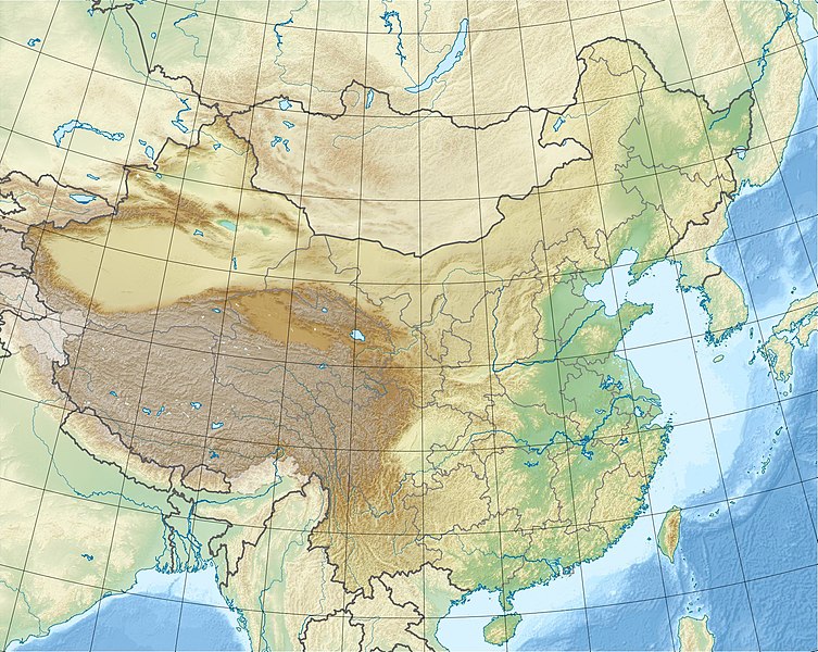
English: Location map of China.
EquiDistantConicProjection : Central parallel : * N: 36.0° N Central meridian : * E: 104.0° E Standard parallels : * 1: 30.0° N * 2: 42.0° N Latitudes on the central meridian : * top: 57.0° N * center: 37.29° N * bottom: 17.96° NMade with Natural Earth. Free vector and raster map data @ naturalearthdata.com. |
| Datum | |
| Quälle | Eigeni Arbet |
| Urheber | Uwe Dedering |
| Anderi Versione |
|


Abgleiteti Wärk vo dere Datei: China edcp relief location map Sichuan.png
Lizänzierig
Ich haa s Urheberrächt an däm Wärch un vereffetlig s dodermit unter däne Lizänze:
Die Datei isch lizänziert unter dr Creative-Commons-Lizenz Namensnännig – Wytergab unter glyche Bedingige 3.0 nit portiert.
- Du derfsch:
- des Wärch an anderi wytergee – des Wärch kopiere, verbreite un ibertrage
- des Wärch verändere – des Wärch aapasse
- Unter däne Bedingige:
- Namenännig – Du muesch aagmässeni Aagabe zum Urheber un dr Rächt mache, e Link zue dr Lizänz zuefiege un aagee, eb Änderige gmacht wore sin. Die Aagabe chenne in ere aagmässene Art gmacht wäre, aber nit eso, ass dr Yydruck entstoht, ass dr Lizänzgeber Dii oder Dyy Gebruch vum Wärch unterstitze un guetheiße.
- Wytergab unter glyche Bedingige – Wänn du des Wärch veränderesch, umwandlesch oder druf ufböusch, no derfsch s Ergebnis nume unter dr glyche oder ere kumpatible Lizänz wie s Orginal vereffetlige.

|
Des Dokumänt derf kopiert, verbreitet un/oder bearbeitet wäre unter dr Bedingige vu dr GNU-Lizänz fir freji Dokumäntation, Version 1.2 oder ere spetere Version, vereffetligt dur Free Software Foundation. S het keini uuveränderlige Abschnitt, kei vordere Umschlagstext un kei hindere Umschlagstext. E Kopii vu dr Lizänz isch verfiegbar im Abschnitt GNU-Lizänz fir freji Dokumäntation. |
Du chasch sälber e Lizänz uuswehle.
Dateiversione
Klick uf e Zytpunkt zu aazeige, wie s dert usgsäh het.
| Version vom | Vorschaubild | Mäß | Benutzer | Kommentar | |
|---|---|---|---|---|---|
| aktuell | 13:47, 3. Mär. 2010 | | 1.968 × 1.567 (562 KB) | Uwe Dedering | {{Information |Description={{en|1=Location map of China. EquiDistantConicProjection. Center: * N: 36.0° N * E: 104.0° E Standard parallels: * 1: 30.0° E * 2: 42.0° E Made with Natural Earth. Free vector and raster map data @ naturalearthdata.com. |
Verwändig vu dr Datei
Di folgende Sytene händ en Link zu dem Bildli:
Wältwyti Dateinutzig
Die andere Wikis bruche die Datei:
- Gebruch uf ace.wikipedia.org
- Gebruch uf am.wikipedia.org
- Gebruch uf ar.wikipedia.org
- Gebruch uf arz.wikipedia.org
- Gebruch uf ast.wikipedia.org
- Gebruch uf az.wikipedia.org
- Himalay
- Sarı dəniz
- Tyanşan
- Şensi zəlzələsi (1556)
- Everest
- Qansuda zəlzələ
- Panjin çimərliyi
- Şablon:Yer xəritəsi Çin
- Şərqi Çin dənizi
- Tanşan zəlzələsi (1976)
- Ludyan zəlzələsi (2014)
- Tayvan boğazı
- Haynan boğazı
- Qərbi Koreya körfəzi
- Leyçjoubandao yarımadası
- Üç dərə SES
- Haynan
- Kukunor
- Dumtinxu
- Xanka gölü
- Təkləməkan
- Qobi
- Qaşun Qobisi
- Cunqariya
- Tibet yaylası
- Jexe yaylası
- Böyük Ussurskiy
- Üç paralel çay
- Damansk adası
- Alaşan
- Hami səhrası
- Kubuqi
- Ordos
- Mu-Us
- Tenqer (səhra)
- Badın-Jaran
- Dzosotın-Elisun
- Çaydam
- Qanqdis
- Pektusan dağı
Wältwyti Verwändig vu däre Datei aaluege.