Originaldatei(1.894 × 1.367 Pixel, Dateigrößi: 195 KB, MIME-Typ: image/png)

Die Datei un d Informatione derzue were us em zäntrale Mediearchiv Wikimedia Commons (Allmänd) iibunde. Zur Bschriibigssite uff de Allmänd Zur Bschriibigssite uff de Allmänd
Dieses Bild des Typs Historical map sollte als Vektorgrafik im SVG-Format neu erstellt werden. Vektorformate haben zahlreiche Vorteile; weitere Information unter Commons:Media for cleanup. Wenn dir eine SVG-Version dieses Bildes vorliegt, so lade diese bitte hoch. Nach dem Hochladen der Datei ist diese Vorlage auf der aktuellen Bildbeschreibungsseite durch die Vorlage {{Vector version available}}, oder kürzer {{Vva}}, zu ersetzen. Es ist empfohlen die neue SVG-Datei „Europe map 1648.svg“ zu nennen – dann benötigt die Vorlage vector version available (bzw. vva) keinen Parameter.

Bschryybig

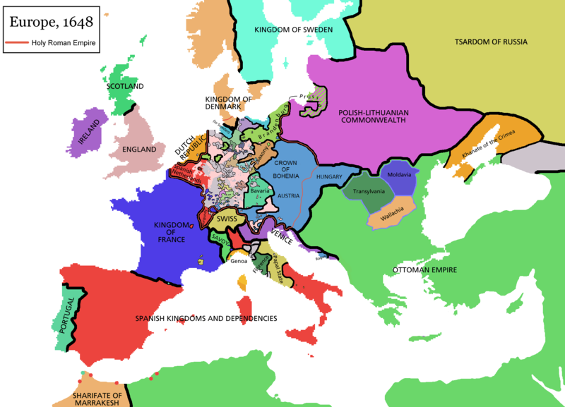
Map of Europe in 1648 (at the end of the Thirty Years War), based on free map of europe Image:BlankMap-Europe.png. Red line marks the border of the Holy Roman Empire. Information from Penguin atlas of modern history. (what year?)

Historische Karten von Europa
BCE
aC

Weichselian ice age (c. 113,000–9700) · Neolithic expansion (c. 7000–4500) · mittlere Jungsteinzeit (c. 4500–4000) · späte Jungsteinzeit (c. 4000–3000) · Copper Age – Corded Ware culture (c. 2900–2350) · Copper Age – Bellbeaker culture (c. 2800–1800) · Early Bronze Age – Unetice culture (c. 2300–1600) · Late Bronze Age – Urnfield culture (c. 1300—750) · Migrations (c. 1000–100) · Hallstatt & La Tène cultures (c. 800–100) · Roman Republic (510–40) · 220 · 218 · 200 · 201–100 · 58 · 49 · 39 · 30 BCE–6 CE


CE
dC

14 · 14–37 · 60 · 60 · 69 · 80 · Völkerwanderung 100–500 · 117 · 117 · 125 · Völkerwanderung 150–774 · Economy 180 · 271 · 293–305 · 337 · 395 · c. 395 · 400 · 400 · 450 · 457–61 · 476 · 480 · Franken 481–814 · frühe Slawen 500–700 · 500 · 526 · 526–600 · Christianisierung bis 600 · c. 550 · 650 · Pontokaspis 650 · 665 · 800 · Wikinger 800–1050 · 814 · 843–70 · 850 · 900 · 912 · 998 · 1000 · 1000 · 1054 · 1092 · First Crusade 1095–99 · 1097 · 1135 · 1142 · 1147–49 · 1190 · 1190 · 1250 · c. 1250 · 1301-1400 · 1301-1400 · 1328 · 1345 · Schwarzer Tod 1347–51 · 1360 · 1400 · Handelswege c. 1400 · 1430 · 1470 · 1490 · 1492 · 1500 · 1519 · 1550 · 1560 · Religion 1560 · Religion 1600 · Religion 1618 · 1618–48 · 1648 · 1683 · 1700 · 1701 · 1708 · 1714 · 1721 · 1725–30 · 1739–1740 · 1740 · 1748–66 · 1783–1792 · 1787 · 1787 · 1789 · 1799 · 1812 · 1812 · 1812 · 1812 · 1813 · 1815 · 1815 · 1815 · 1818 · Osmanisches Reich 1830–1923 · 1848–49 · 1861 · 1867 · 1871 · 1878 · 1890 · 1905 · 1911 · 1914 · 1914 · 1919 · 1919–29 · 1923 · 1929 · 1930 · 1940 · 1941–42 · 1942–45 · Kalter Krieg 1947–91 · 1950 · 1993–2006 · 2006 bis heute

(diese Vorlage: · zeigen · diskutieren )


Lizänzierig

GNU head Des Dokumänt derf kopiert, verbreitet un/oder bearbeitet wäre unter dr Bedingige vu dr GNU-Lizänz fir freji Dokumäntation, Version 1.2 oder ere spetere Version, vereffetligt dur Free Software Foundation. S het keini uuveränderlige Abschnitt, kei vordere Umschlagstext un kei hindere Umschlagstext. E Kopii vu dr Lizänz isch verfiegbar im Abschnitt GNU-Lizänz fir freji Dokumäntation.
w:als:Creative Commons
Namenännig Wytergab unter glyche Bedingige
Die Datei isch lizänziert unter dr Creative-Commons-Lizenz Namensnännig – Wytergab unter glyche Bedingige 3.0 nit portiert.
Du derfsch:
  • des Wärch an anderi wytergee – des Wärch kopiere, verbreite un ibertrage
  • des Wärch verändere – des Wärch aapasse
Unter däne Bedingige:
  • Namenännig – Du muesch aagmässeni Aagabe zum Urheber un dr Rächt mache, e Link zue dr Lizänz zuefiege un aagee, eb Änderige gmacht wore sin. Die Aagabe chenne in ere aagmässene Art gmacht wäre, aber nit eso, ass dr Yydruck entstoht, ass dr Lizänzgeber Dii oder Dyy Gebruch vum Wärch unterstitze un guetheiße.
  • Wytergab unter glyche Bedingige – Wänn du des Wärch veränderesch, umwandlesch oder druf ufböusch, no derfsch s Ergebnis nume unter dr glyche oder ere kumpatible Lizänz wie s Orginal vereffetlige.
Die Lizänzmarkierig isch wäg em GFDL-Lizänzupdate zuegfiegt wore.

derivative works

Abgleiteti Wärk vo dere Datei:

Kurzbeschreibungen

Ergänze eine einzeilige Erklärung, was diese Datei darstellt.

In dieser Datei abgebildete Objekte

Motiv

MIME-Typ Tüütsch

image/png

Dateiversione

Klick uf e Zytpunkt zu aazeige, wie s dert usgsäh het.

(Nöischti | Eltischti) (nächschti 10) () aazeige; (10 | 20 | 50 | 100 | 250 | 500) uf ds Mal
Version vomVorschaubildMäßBenutzerKommentar
aktuell11:44, 14. Apr. 2021Vorschaubild fir Version vum 11:44, 14. Apr. 20211.894 × 1.367 (195 KB)TenanReverted to version as of 16:09, 12 October 2017 (UTC) See discussion
12:47, 9. Mär. 2021Vorschaubild fir Version vum 12:47, 9. Mär. 20211.894 × 1.367 (210 KB)TTBCamhReverted to version as of 17:18, 20 September 2018 (UTC). I don't know why Raderich is saying this is an arbitrary change—Catalonia was under the possession of the French king in 1648, following the Catalan Revolt of 1640. This map is correct and the previous one is incorrect.
14:12, 25. Sep. 2018Vorschaubild fir Version vum 14:12, 25. Sep. 20181.894 × 1.367 (195 KB)RaderichReverted to version as of 21:15, 18 September 2018 (UTC) Undone arbitrary changes. Revert to correct map as uploaded by its creator Roke~commonswiki
19:18, 20. Sep. 2018Vorschaubild fir Version vum 19:18, 20. Sep. 20181.894 × 1.367 (210 KB)AmbroiseLThe Catalan counties were French since they proclaimed Louis XIV of France as their king. They wanted to be French in order not to obey the king of Spain anymore. Courland was a quite free vassal state of Poland. The reverted version doesn't show it. The reverted version also doesn't show the Venetian islands in the Adriatic Sea, and the Algerian towns that France occupied. Hence, I re-revert to the more precise version.
23:15, 18. Sep. 2018Vorschaubild fir Version vum 23:15, 18. Sep. 20181.894 × 1.367 (195 KB)RaderichReverted to version as of 16:09, 12 October 2017 (UTC)
12:45, 19. Jul. 2018Vorschaubild fir Version vum 12:45, 19. Jul. 20181.894 × 1.367 (210 KB)AmbroiseLReverted to version as of 12:06, 20 January 2017 (UTC) — reverted to the version with fixed names, my mistake
12:37, 19. Jul. 2018Vorschaubild fir Version vum 12:37, 19. Jul. 20181.894 × 1.367 (150 KB)AmbroiseLReverted to version as of 10:33, 24 September 2016 (UTC)
18:09, 12. Okt. 2017Vorschaubild fir Version vum 18:09, 12. Okt. 20171.894 × 1.367 (195 KB)Reverted to version as of 12:42, 9 September 2016 (UTC) why is Catalonia French? Not shown as such on File:Europe_1648_westphal_1884.jpg
14:06, 20. Jan. 2017Vorschaubild fir Version vum 14:06, 20. Jan. 20171.894 × 1.367 (210 KB)FakirbakirNames of Austria, Bohemia and Hungary are fixed.
12:33, 24. Sep. 2016Vorschaubild fir Version vum 12:33, 24. Sep. 20161.894 × 1.367 (150 KB)AmbroiseLAdjunction of polish-lithuanian vassal state of Courland
(Nöischti | Eltischti) (nächschti 10) () aazeige; (10 | 20 | 50 | 100 | 250 | 500) uf ds Mal

Di folgende Sytene händ en Link zu dem Bildli:

Wältwyti Dateinutzig

Die andere Wikis bruche die Datei:

Wältwyti Verwändig vu däre Datei aaluege.

Metadate