Datei:Karte Sprachen Graubünden.png

Greßi vu däre Vorschau: 648 × 600 Pixel. Wyteri Ufflösige: 259 × 240 Pixel | 519 × 480 Pixel | 900 × 833 Pixel.
Originaldatei (900 × 833 Pixel, Dateigrößi: 190 KB, MIME-Typ: image/png)
| Die Datei un d Informatione derzue were us em zäntrale Mediearchiv Wikimedia Commons (Allmänd) iibunde. | Zur Bschriibigssite uff de Allmänd |

|
Dieses Bild des Typs Linguistic map sollte als Vektorgrafik im SVG-Format neu erstellt werden. Vektorformate haben zahlreiche Vorteile; weitere Information unter Commons:Media for cleanup. Wenn dir eine SVG-Version dieses Bildes vorliegt, so lade diese bitte hoch. Nach dem Hochladen der Datei ist diese Vorlage auf der aktuellen Bildbeschreibungsseite durch die Vorlage {{Vector version available}}, oder kürzer {{Vva}}, zu ersetzen. Es ist empfohlen die neue SVG-Datei „Karte Sprachen Graubünden.svg“ zu nennen – dann benötigt die Vorlage vector version available (bzw. vva) keinen Parameter.
|
Bschryybig
| Bschryybig |
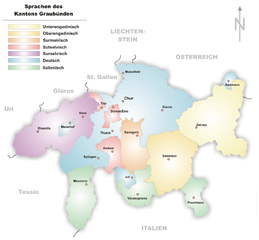
source: http://de.wikipedia.org/wiki/Bild:Karte_Sprachen_Graubünden.png Sprachregionen im Kanton Graubünden, selbstgezeichnet von Tschubby |
| Datum | 29. Novämber 2005 (Original-Hochladedatum) |
| Quälle | No machine-readable source provided. Own work assumed (based on copyright claims). |
| Urheber | No machine-readable author provided. Wiki-vr assumed (based on copyright claims). |
Lizänzierig
| Ich, dr Urheberrächtsinhaber vu däm Wärch, tue s as gmeinfrej vereffentlige . Des giltet wältwyt. In mänke Staate chennt des rächtli nit megli syy. Wänn des imfall eso isch: Ich gib e jedem s bedingiglos Rächt, des Wärch jedwädere Zwäck z nutze, ußer s git gesetzlig erforderligi Bedingige. |
Dateiversione
Klick uf e Zytpunkt zu aazeige, wie s dert usgsäh het.
| Version vom | Vorschaubild | Mäß | Benutzer | Kommentar | |
|---|---|---|---|---|---|
| aktuell | 11:07, 4. Dez. 2005 | | 900 × 833 (190 KB) | Wiki-vr | small corrections |
| 17:40, 29. Nov. 2005 |  | 902 × 833 (190 KB) | Wiki-vr | source: http://de.wikipedia.org/wiki/Bild:Karte_Sprachen_Graubünden.png Sprachregionen im Kanton Graubünden, selbstgezeichnet von Tschubby Category:Maps of Canton of Grisons |
Verwändig vu dr Datei
Di folgende Sytene händ en Link zu dem Bildli:
Wältwyti Dateinutzig
Die andere Wikis bruche die Datei:
- Gebruch uf cs.wikipedia.org
- Gebruch uf de.wikipedia.org
- Gebruch uf eo.wikipedia.org
- Gebruch uf eu.wikipedia.org
- Gebruch uf fr.wikipedia.org
- Gebruch uf hu.wikipedia.org
- Gebruch uf la.wikipedia.org
- Gebruch uf lmo.wikipedia.org
- Gebruch uf ln.wikipedia.org
- Gebruch uf sv.wikipedia.org