Datei:Plan tramway reims.png
Greßi vu däre Vorschau: 271 × 600 Pixel. Wyteri Ufflösige: 108 × 240 Pixel | 217 × 480 Pixel | 1.000 × 2.213 Pixel.
Originaldatei (1.000 × 2.213 Pixel, Dateigrößi: 2,33 MB, MIME-Typ: image/png)
| Die Datei un d Informatione derzue were us em zäntrale Mediearchiv Wikimedia Commons (Allmänd) iibunde. | Zur Bschriibigssite uff de Allmänd |
Bschryybig
| Bschryybig |
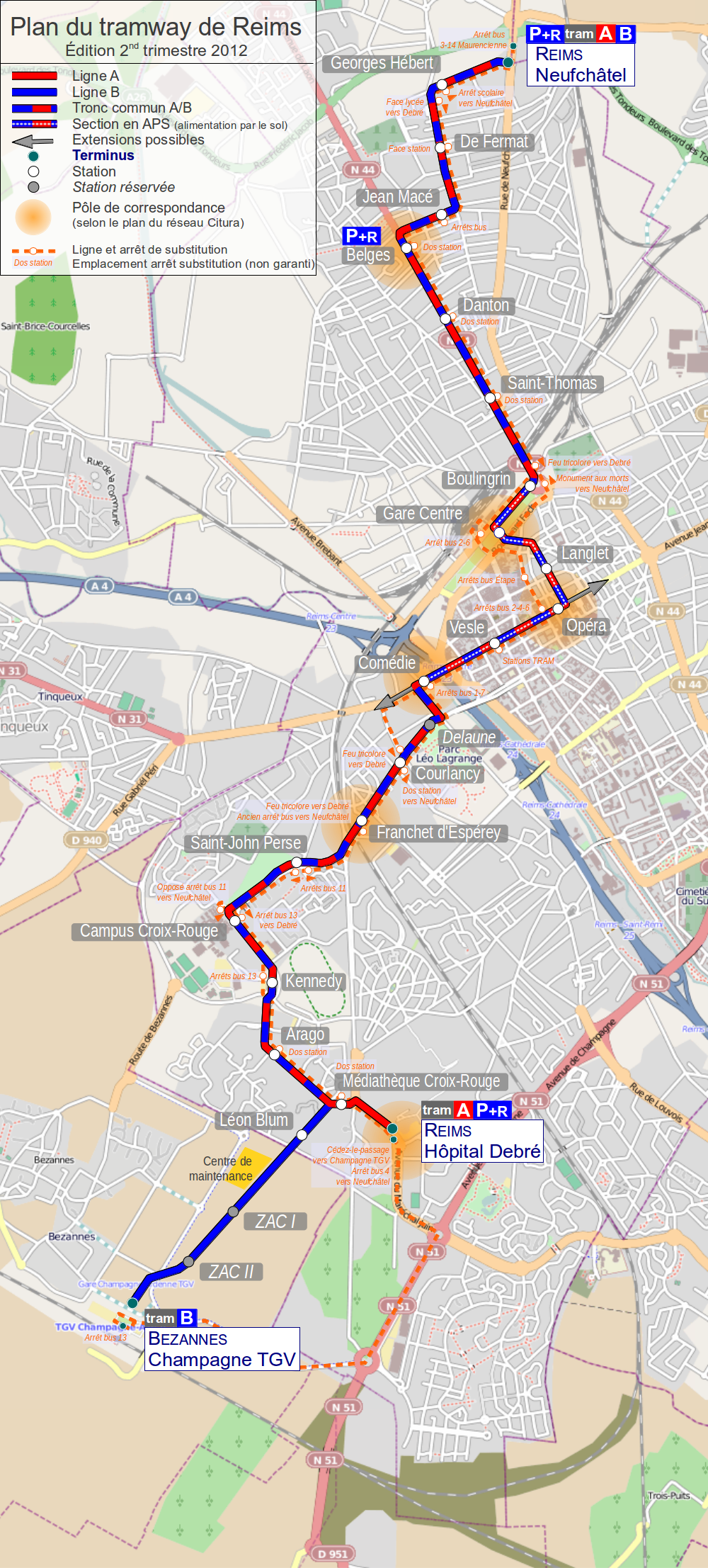
English: Map of tramway in Rheims France
Français : Plan du tramway de Reims, France |
| Datum | |
| Quälle | Eigeni Arbet. Background map: © OpenStreetMap and contributors, CC BY-SA. |
| Urheber | Daiima |
Lizänzierig
Die Datei isch lizänziert unter dr Creative-Commons-Lizänz Namensnännig – Wytergab unter glyche Bedingige 2.0 generisch.
- Du derfsch:
- des Wärch an anderi wytergee – des Wärch kopiere, verbreite un ibertrage
- des Wärch verändere – des Wärch aapasse
- Unter däne Bedingige:
- Namenännig – Du muesch aagmässeni Aagabe zum Urheber un dr Rächt mache, e Link zue dr Lizänz zuefiege un aagee, eb Änderige gmacht wore sin. Die Aagabe chenne in ere aagmässene Art gmacht wäre, aber nit eso, ass dr Yydruck entstoht, ass dr Lizänzgeber Dii oder Dyy Gebruch vum Wärch unterstitze un guetheiße.
- Wytergab unter glyche Bedingige – Wänn du des Wärch veränderesch, umwandlesch oder druf ufböusch, no derfsch s Ergebnis nume unter dr glyche oder ere kumpatible Lizänz wie s Orginal vereffetlige.
Dateiversione
Klick uf e Zytpunkt zu aazeige, wie s dert usgsäh het.
| Version vom | Vorschaubild | Mäß | Benutzer | Kommentar | |
|---|---|---|---|---|---|
| aktuell | 22:43, 2. Apr. 2012 | | 1.000 × 2.213 (2,33 MB) | Daiima | Visiblement l'upload s'est mal déroulé, nouvelle tentative |
| 22:39, 2. Apr. 2012 |  | 1.000 × 2.213 (2,33 MB) | Daiima | Ajout ligne substitution | |
| 15:50, 29. Aug. 2011 |  | 695 × 1.538 (1,31 MB) | Daiima | Mise à jour rentrée 2011 ligne B jusqu'à Neufchâtel | |
| 20:16, 7. Feb. 2011 |  | 695 × 1.538 (3,06 MB) | Daiima | stations projetées sur bezannes | |
| 00:12, 29. Dez. 2010 |  | 695 × 1.538 (3,06 MB) | Daiima | updates | |
| 17:36, 12. Okt. 2010 |  | 695 × 1.538 (3,06 MB) | Daiima | + Centre de Maintenance | |
| 14:15, 12. Okt. 2010 |  | 695 × 1.538 (3,06 MB) | Daiima | + Park-and-Ride | |
| 14:08, 12. Okt. 2010 |  | 695 × 1.538 (3,06 MB) | Daiima | {{Information |Description={{en|1=Map of tramway in Rheims France}} {{fr|1=Plan du tramway de Reims, France}} |Source={{own}} |Author=Daiima |Date=2010/10/12 |Permission= |other_versions= }} Category:Public transport maps of Reims |
Verwändig vu dr Datei
Di folgende Sytene händ en Link zu dem Bildli:
Wältwyti Dateinutzig
Die andere Wikis bruche die Datei:
- Gebruch uf de.wikipedia.org
- Gebruch uf eo.wikipedia.org
- Gebruch uf fr.wikipedia.org
- Gebruch uf hu.wikipedia.org
- Gebruch uf it.wikipedia.org
- Gebruch uf ja.wikipedia.org
- Gebruch uf nl.wikipedia.org
- Gebruch uf pl.wikipedia.org
- Gebruch uf ru.wikipedia.org
- Gebruch uf uk.wikipedia.org
- Gebruch uf www.wikidata.org