Datei:Six Day War Territories 2.png
Kei höcheri Uflösig verfüegbar.
Six_Day_War_Territories_2.png (398 × 599 Pixel, Dateigrößi: 52 KB, MIME-Typ: image/png)
| Die Datei un d Informatione derzue were us em zäntrale Mediearchiv Wikimedia Commons (Allmänd) iibunde. | Zur Bschriibigssite uff de Allmänd |
Bschryybig

|
Please translate the English parts of this template into Alemannisch.
Säll Bild gitt's au in als Vektorgrafik (SVG). Wenn's besser isch, no benutz säll anstell vu dem Rasterbild. File:Six Day War Territories 2.png → File:Six Day War Terrritories.svg
Meh zu Vektorgrafike findsch unter Wechsel zu SVG. Zu de Unterstützig vu SVG durch d'MediaWiki-Software lüeg unter SVG image support uff Meta. |
 |
| Bschryybig |
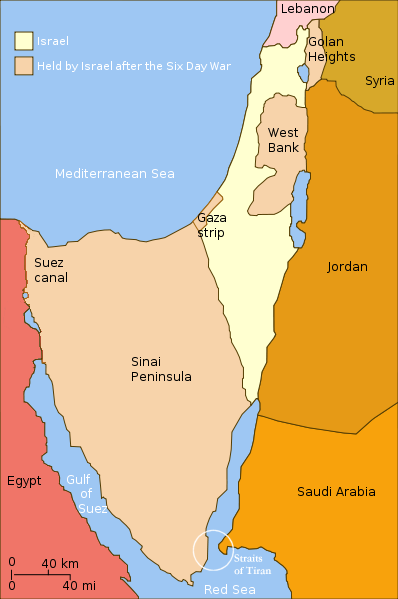
English: Israel and the territories Israel occupied in the Six day war. |
| Datum | (UTC) |
| Quälle | |
| Urheber |
|
| Anderi Versione |
[]
|


.png)


| Dieses Bild wurde digital nachbearbeitet. Folgende Änderungen wurden vorgenommen: Changed "Israeli territory before the Six day war" to "Israel", since Israels territory before the Six day war is the same as after. Das Originalbild kann hier eingesehen werden: Six Day War Terrritories.png:
|
Ich haa s Urheberrächt an däm Wärch un vereffetlig s dodermit unter däre Lizänz:
Die Datei isch lizänziert unter dr Creative-Commons-Lizenz Namensnännig – Wytergab unter glyche Bedingige 2.5 generisch.
- Du derfsch:
- des Wärch an anderi wytergee – des Wärch kopiere, verbreite un ibertrage
- des Wärch verändere – des Wärch aapasse
- Unter däne Bedingige:
- Namenännig – Du muesch aagmässeni Aagabe zum Urheber un dr Rächt mache, e Link zue dr Lizänz zuefiege un aagee, eb Änderige gmacht wore sin. Die Aagabe chenne in ere aagmässene Art gmacht wäre, aber nit eso, ass dr Yydruck entstoht, ass dr Lizänzgeber Dii oder Dyy Gebruch vum Wärch unterstitze un guetheiße.
- Wytergab unter glyche Bedingige – Wänn du des Wärch veränderesch, umwandlesch oder druf ufböusch, no derfsch s Ergebnis nume unter dr glyche oder ere kumpatible Lizänz wie s Orginal vereffetlige.
Orginal Logbuech vu uffegladene Datei
This image is a derivative work of the following images:
- File:Six_Day_War_Terrritories.png licensed with Cc-by-sa-2.5
- 2010-11-11T21:32:04Z 99of9 398x599 (53810 Bytes) Reverted to version as of 07:04, 25 July 2010. Both POV versions should be at different locations, marked with POV and linked.
- 2010-11-08T11:06:48Z Supreme Deliciousness 398x599 (53223 Bytes) Israeli territory before the Six day war is the same as after the Six day war.
- 2010-07-25T07:04:14Z Ling.Nut 398x599 (53810 Bytes) {{Information |Description={{en|1=Israeli territories before and after the Six Day War. The Straits of Tiran are circled, between the Gulf of Aqaba, and the Red Sea.}} |Source=Yom Kippur War map.svg |Author=[[User:Ling.Nut]]
Hochgeladen mit derivativeFX
Dateiversione
Klick uf e Zytpunkt zu aazeige, wie s dert usgsäh het.
| Version vom | Vorschaubild | Mäß | Benutzer | Kommentar | |
|---|---|---|---|---|---|
| aktuell | 14:15, 12. Nov. 2010 | | 398 × 599 (52 KB) | Supreme Deliciousness | {{Information |Description={{en|1=Israel and the territories Israel occupied in the Six day war.</br>in yellow: Israel within the "Green Line" borders (per 1949 ceasefire agreements); in light maroon: Territories Israel seized during |
Verwändig vu dr Datei
Di folgende Sytene händ en Link zu dem Bildli:
Wältwyti Dateinutzig
Die andere Wikis bruche die Datei:
- Gebruch uf da.wikipedia.org
- Gebruch uf en.wikipedia.org
- Gebruch uf fr.wikipedia.org
- Gebruch uf gl.wikipedia.org
- Gebruch uf ja.wikipedia.org
- Gebruch uf my.wikipedia.org
- Gebruch uf no.wikipedia.org
- Gebruch uf pl.wikipedia.org
- Gebruch uf sh.wikipedia.org
- Gebruch uf sv.wikipedia.org
- Gebruch uf sv.wikiversity.org
- Gebruch uf ta.wikipedia.org