Datei:Sumatra Locator Topography.png
Greßi vu däre Vorschau: 559 × 600 Pixel. Wyteri Ufflösige: 224 × 240 Pixel | 447 × 480 Pixel | 716 × 768 Pixel | 954 × 1.024 Pixel | 1.866 × 2.002 Pixel.
Originaldatei (1.866 × 2.002 Pixel, Dateigrößi: 2,26 MB, MIME-Typ: image/png)
| Die Datei un d Informatione derzue were us em zäntrale Mediearchiv Wikimedia Commons (Allmänd) iibunde. | Zur Bschriibigssite uff de Allmänd |
Bschryybig
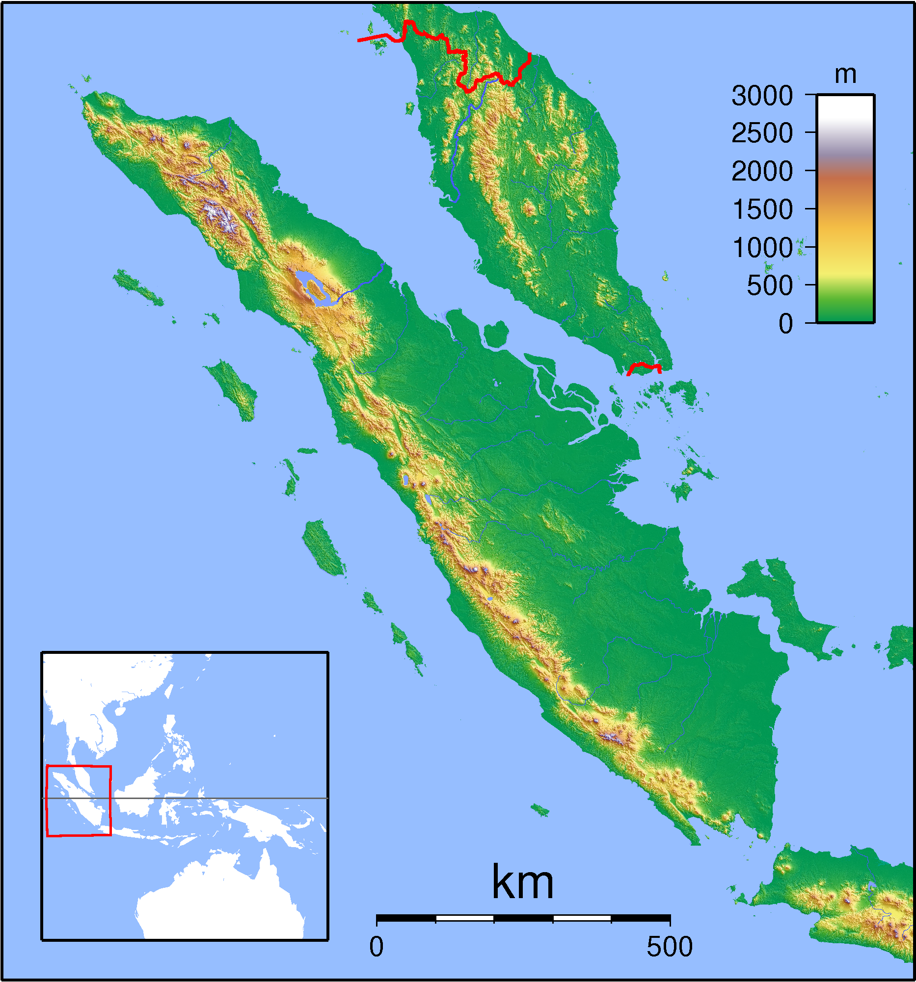
| Bschryybig | Topographic locator map of Sumatra. Created with GMT from SRTM data. For non-locator version, see Image:Sumatra Topography.png. Left:94 Bottom:-8 Rght:108 Top:7 |
| Datum | |
| Quälle | Eigeni Arbet |
| Urheber | Sadalmelik |
Lizänzierig
Ich haa s Urheberrächt an däm Wärch un vereffetlig s dodermit unter däne Lizänze:

|
Des Dokumänt derf kopiert, verbreitet un/oder bearbeitet wäre unter dr Bedingige vu dr GNU-Lizänz fir freji Dokumäntation, Version 1.2 oder ere spetere Version, vereffetligt dur Free Software Foundation. S het keini uuveränderlige Abschnitt, kei vordere Umschlagstext un kei hindere Umschlagstext. E Kopii vu dr Lizänz isch verfiegbar im Abschnitt GNU-Lizänz fir freji Dokumäntation. |
Die Datei isch lizänziert unter dr Creative-Commons-Lizänze Namensnännig – Wytergab unter glyche Bedingige 3.0 nit portiert, 2.5 generisch, 2.0 generisch un 1.0 generisch.
- Du derfsch:
- des Wärch an anderi wytergee – des Wärch kopiere, verbreite un ibertrage
- des Wärch verändere – des Wärch aapasse
- Unter däne Bedingige:
- Namenännig – Du muesch aagmässeni Aagabe zum Urheber un dr Rächt mache, e Link zue dr Lizänz zuefiege un aagee, eb Änderige gmacht wore sin. Die Aagabe chenne in ere aagmässene Art gmacht wäre, aber nit eso, ass dr Yydruck entstoht, ass dr Lizänzgeber Dii oder Dyy Gebruch vum Wärch unterstitze un guetheiße.
- Wytergab unter glyche Bedingige – Wänn du des Wärch veränderesch, umwandlesch oder druf ufböusch, no derfsch s Ergebnis nume unter dr glyche oder ere kumpatible Lizänz wie s Orginal vereffetlige.
Du chasch sälber e Lizänz uuswehle.
Dateiversione
Klick uf e Zytpunkt zu aazeige, wie s dert usgsäh het.
| Version vom | Vorschaubild | Mäß | Benutzer | Kommentar | |
|---|---|---|---|---|---|
| aktuell | 20:56, 1. Sep. 2007 | | 1.866 × 2.002 (2,26 MB) | Sadalmelik | {{Information |Description=Topographic locator map of Sumatra. Created with GMT from SRTM data. For non-locator version, see Image:Sumatra Topography.png. Left:94 Bottom:-8 Rght:108 Top:7 |Source=self-made |Date=Sep 1, 2007 |Author= [[User:Sadalmelik |
Verwändig vu dr Datei
Kei Artikel bruucht die Datei.
Wältwyti Dateinutzig
Die andere Wikis bruche die Datei:
- Gebruch uf ace.wikipedia.org
- Gebruch uf ar.wikipedia.org
- Gebruch uf ban.wikipedia.org
- Gebruch uf ceb.wikipedia.org
- Gebruch uf de.wikipedia.org
- Gebruch uf en.wikipedia.org
- Gebruch uf es.wikipedia.org
- Gebruch uf fa.wikipedia.org
- Gebruch uf hu.wikipedia.org
- Gebruch uf id.wikipedia.org
- Gebruch uf it.wikipedia.org
- Gebruch uf it.wikivoyage.org
- Gebruch uf ja.wikipedia.org
- Gebruch uf ka.wikipedia.org
- Gebruch uf kn.wikipedia.org
- Gebruch uf min.wikipedia.org
- Gebruch uf mk.wikipedia.org
- Gebruch uf ml.wikipedia.org
- Gebruch uf ms.wikipedia.org
Wältwyti Verwändig vu däre Datei aaluege.