Haut-Valromey
französeschi Gmaind im Département Ain
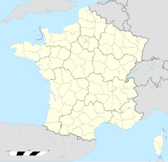
Haut-Valromey isch e franzesische Gmai im Département Ain i dr Region Auvergne-Rhône-Alpes. D Gmai ghert zum Kanton Hauteville-Lompnes im Arrondissement Belley.
| Haut-Valromey | |
 | |
| Verwàltung | |
|---|---|
| Land | |
| Region | |
| Département | Ain (01) |
| Arrondissement | Nantua |
| Kànton | Hauteville-Lompnes |
| Kommünàlverbànd | Bugey Sud |
| Àmtliga Nàma | Haut-Valromey |
| Maire | Bernard Ancian (2014-2020)[1] |
| Code Insee | 01187 |
| Poschtlaitzàhl | 01260 |
| Iiwohner | |
| Iiwohner | 603 |
| Flech | 107,85 km2 |
| Bevelkerungsdicht | 2,91 Iiw./km2 |
| Làg | |
| Koordinate | 45° 59′ 51″ N, 5° 41′ 42″ E / 45.9975°N,5.695°EKoordinate: 45° 59′ 51″ N, 5° 41′ 42″ E / 45.9975°N,5.695°E |
| Heche | 567−1,338 m |
| Website | |
| http://www.hautvalromey.fr | |
Geografii
ändereD Nachbergmeinde vo Haut-Valromey sind Les Neyrolles im Nordweschte, Le Poizat-Lalleyriat im Norde, Châtillon-en-Michaille un Villes im Nordoschte, Billiat, Injoux-Génissiat und Lhôpital im Oschte, Chanay und Corbonod im Südoschte, Champagne-en-Valromey und Brénaz im Süde, Lompnieu und Ruffieu im Südweschte und Champdor-Corcelles und Brénod im Weschte.
Gschicht
ändereSi isch am 1. Jänner 2016 durch d Fusion vo de bisherige Gmeinde Hotonnes, Le Grand-Abergement, Le Petit-Abergement und Songieu entschtande.
Weblingg
ändere Commons: Haut-Valromey – Sammlig vo Multimediadateie
Fuessnote
ändere- ↑ Liste des maires au 25 avril 2014 (data.gouv.fr)
