Carantec
Carantec (bretonisch Karanteg) isch e franzesischi Gmai im Département Finistère in dr Region Bretagne.
| Carantec | |
 Carantec, Plage du Kélenn | |
| Verwàltung | |
|---|---|
| Land | |
| Region | |
| Département | Finistère (29) |
| Arrondissement | Morlaix |
| Kànton | Morlaix |
| Kommünàlverbànd | Morlaix Communauté |
| Àmtliga Nàma | Carantec |
| Maire | Nicole Segalen-Hamon (2014-2020)[1] |
| Code Insee | 29023 |
| Poschtlaitzàhl | 29660 |
| Iiwohner | |
| Iiwohner | 3.236 |
| Flech | 9,02 km2 |
| Bevelkerungsdicht | 360,2 Iiw./km2 |
| Làg | |
| Koordinate | 48° 40′ 04″ N, 3° 54′ 49″ W / 48.667777777778°N,3.9136111111111°WKoordinate: 48° 40′ 04″ N, 3° 54′ 49″ W / 48.667777777778°N,3.9136111111111°W |
| Heche | 40 m |
 Carantec Carantec (Frànkrich) | |
| Website | |
| http://www.ville-carantec.com | |
D Gmai ghert zum Kanton Morlaix un zum Arrondissement Morlaix.
Geografi
ändereCarantec lyt am Atlantik an dr Baie de Morlaix, zwische dr Mindige vum Penzé im Weschte un vum Morlaix im Oschte, 76 km vu Quimper un 53 km vu Brest uf ere Hechi zwische 0 m un 74 m iber Normalnull. D Nochbergmaine sin Saint-Pol-de-Léon un Roscoff im Nordweschte, Plougasnou im Nordoschte, Plouezoc’h im Oschte, Henvic im Sidweschte, Taulé im Side un Locquénolé un Morlaix im Sidoschte. Zue dr Gmai ghere au no d Insle Île Louët un Île Callot.
Gschicht
ändereCarantec isch zum erschte Mol gnännt wore anne 1434 as Karantec (1630 Quarente).
Verwaltig
ändereD Maire vu Carantec isch d Nicole Segalen-Hamon. Carantec ghert zum Kommunalverband Morlaix Communauté.
Bevelkerigsentwicklig
ändere| Johr | 1962 | 1968 | 1975 | 1982 | 1990 | 1999 | 2008 |
| Inwohner | 2.603 | 2.651 | 2.527 | 2.522 | 2.609 | 2.724 | 3.309 |
Dialekt
ändereDr traditionäll Dialäkt vu Carantec ghert zem Bretonisch.
Kultur un Böuwärch
ändere- Chilche Saint-Carantec
- Kapäll Notre-Dame, Île Callot
- Château du Taureau
Bilder
ändere-
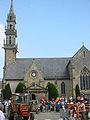
Chilche Saint-Carantec -

Île Louët un Château du Taureau -

Kapäll Notre-Dame, Île Callot -

Alti Schuel, Île Callot -
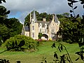
Manoir du Rohou -

Hôtel Geffroy


Partnergmai
ändere Grand-Saconnex, Schwyz
Weblink
ändereFueßnote
ändere- ↑ Liste des maires au 25 avril 2014 (data.gouv.fr)