Collorec
Collorec (bretonisch Koloreg) isch e franzesischi Gmai im Département Finistère in dr Region Bretagne.
| Collorec | |
 | |
| Verwàltung | |
|---|---|
| Land | |
| Region | |
| Département | Finistère (29) |
| Arrondissement | Châteaulin |
| Kànton | Carhaix-Plouguer |
| Kommünàlverbànd | Haute Cornouaille |
| Àmtliga Nàma | Collorec |
| Maire | Georges Croguennec (2014-2020)[1] |
| Code Insee | 29036 |
| Poschtlaitzàhl | 29530 |
| Iiwohner | |
| Iiwohner | 592 |
| Flech | 28,39 km2 |
| Bevelkerungsdicht | 23,46 Iiw./km2 |
| Làg | |
| Koordinate | 48° 17′ 11″ N, 3° 46′ 30″ W / 48.286388888889°N,3.775°WKoordinate: 48° 17′ 11″ N, 3° 46′ 30″ W / 48.286388888889°N,3.775°W |
| Heche | 141 m |
 Collorec Collorec (Frànkrich) | |
D Gmai ghert zum Kanton Carhaix-Plouguer un zum Arrondissement Châteaulin.
Geografi
ändereCollorec lyt 41 km vu Quimper un 54 km vu Brest uf ere Hechi zwische 72 m un 221 m iber Normalnull.
Gschicht
ändereCollorec isch zum erschte Mol gnännt wore anne 1108 as Choloroc (1536 Collorec).
Verwaltig
ändereDr Maire vu Collorec isch dr Georges Croguennec. Collorec ghert zum Kommunalverband Haute Cornouaille.
Bevelkerigsentwicklig
ändere| Johr | 1962 | 1968 | 1975 | 1982 | 1990 | 1999 | 2008 |
| Inwohner | 1.148 | 1.038 | 891 | 778 | 692 | 647 | 667 |
Dialekt
ändereDr traditionäll Dialäkt vu Collorec ghert zem Bretonisch.
Böuwärch
ändere- Chilche Notre-Dame
- Kapäll Sainte-Marguerite
Bilder
ändere-

Chilche Notre-Dame -
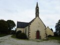
Kapäll Sainte-Marguerite -

Oratoire Sainte-Barbe -
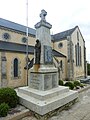
Dotedänkmol


Weblink
ändereFueßnote
ändere- ↑ Liste des maires au 25 avril 2014 (data.gouv.fr)